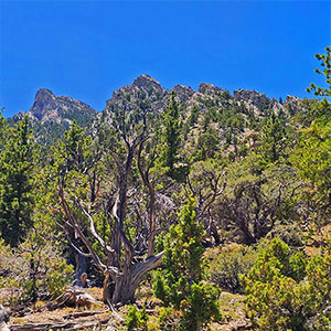
Overview | Mud Springs Loop Trail Clockwise | Sawmill Trailhead | Lee Canyon, Nevada
This is the complete 15-mile outer loop in a
clockwise direction from the
Sawmill Trailhead including a traverse of
Macks Peak Eastern Base. See also the
Mud Springs Counterclockwise Loop including an inner stretch through
Mud Springs and connection to
Macks Canyon Road.
Why two versions of this loop? It’s a long, complicated loop where GPS goes dark the majority of the route and for most of the route there are no directional signs. Each version presents a partially alternate route. I needed to take the loop in both directions to get it right! Be sure to have a route map during your adventure. Especially take note of the half-way point where the trail loops around at the junction of
Mud Springs Road. &
Mud Springs Spur Road. There are no trail signs and the point where the trail resumes off
Mud Springs Spur Road is obscure and easily missed.
Adventure Route Summary
Beginning at the
Sawmill Trailhead start out on the
Sawmill Loop Trail in the clockwise direction. At the next intersection leave the
Sawmill Loop Trail and take a left angling up the ridge to the North. At the ridgeline summit take the next left onto the green coded
Mud Springs Loop Trail. Follow the loop all the way around and emerge on the initial ridgeline summit at the
Mud Springs Loop Trail counterclockwise entrance. Turn right on the ridgeline, pass the clockwise loop entrance where you began the loop earlier. Retrace your way back to the
Sawmill Trailhead.
Best Time of Year for the Mud Springs Loop Trail
Spring or Fall bring the best temperatures. However, a mid-Summer day with temperatures no higher than the mid 90’s in Las Vegas is normally cool enough at the
Mud Springs Loop Trail’s altitude (6,913ft – 7,829ft).
Directions to Start Point | Mud Springs Loop Trail Clockwise | Sawmill Trailhead | Lee Canyon, Nevada
Take
Hwy 95 North from Las Vegas and take a left at the
Lee Canyon Road exit (
Hwy 156). Travel up
Lee Canyon Road about 13 miles. Take a right onto the
Sawmill Trailhead Access Road and proceed to the trailhead. Stay left to reach the upper trailhead parking area.
↓ Narrative Guide ↓
Narrative Guide | Mud Springs Loop Trail Clockwise | Sawmill Trailhead | Lee Canyon, Nevada
Getting Your Initial Bearings
Observe the look of
Mummy’s Head across
Lee Canyon Road. This will be your bomb-proof directional guide back to the trailhead and is seen throughout most of the
Mud Springs Loop Trail. You’ll most likely not go off course (except at the half-way point). The ridgeline of the
Spring Mountains (South to North:
Mummy’s Head, the
Sisters,
Macks Peak,
Bonanza Peak,
Wheeler Peak) will line the South side of the
Mud Springs Loop Trail. The desert terrain through which
Hwy 95 passes between
Las Vegas and
Reno will line the North side of the
Mud Springs Loop Trail. The loop itself is the huge forested Northern slope of the
Spring Mountains.
Copy the Map on This Page and Bring it with You!
The color-coding for Mud Springs Loop directional signs is officially green. However, you won’t see a green-coded directional sign for the first mile or so. During this stretch you will see yellow-coded
Sawmill Loop signs and red-coded
Pinyon Pine Loop Trail signs. Once you enter the
Mud Springs Loop Trail there are only a couple green-coded signs in the entire loop. Most of the
Mud Springs Loop Trail has no directional signs. So, don’t expect directional signs to help you much, or to reassure you that you’re still on the
Mud Springs Loop Trail. Copy the map on this page and bring it with you. You won’t have internet and you won’t have GPS for most of the loop.
Sawmill Trailhead to the Mud Springs Loop Trail Clockwise Entrance
Begin on the
Sawmill Loop clockwise. In about a mile there’s a trail split to the left angling up the ridgeline to your left. That trail is marked red for
Pinyon Pine Loop Trail. Leave the
Sawmill Loop and take that left split up the ridgeline. There are no green-coded directional arrows, but you’re heading toward the
Mud Springs Loop Trail.
At the summit of the ridgeline you’ll see the first green-coded directional arrow splitting off the the left. This is the clockwise entrance for the
Mud Springs Loop Trail. Once you’ve circled the entire loop, you’ll end up back at this intersection, then retrace your way back to the
Sawmill Trailhead.
Notice the terrain as you start out from the
Sawmill Trailhead. Its a lush
Juniper and
Pinyon Pine forest. For most of the loop you’ll be in this type of forest. Its shaded and peaceful. While in the forested areas of the loop, it’s not always easy to keep your sense of direction. But often you’ll ascend to spectacular views of the Limestone
Macks Peak sharply contrasting with the spectacular desert terrain below. The forested areas will eventually include majestic Ponderosa Pine stands with
Bristlecone Pines on the high
limestone ridges and peaks above. Later in the day you’ll descend into the dryer
yucca and
cactus zone. It’s quite the incredible contrast!
Mud Springs Loop Trail Clockwise Entrance to Macks Canyon
As the
Mud Springs Loop Trail descends from its entrance on the upper ridgeline, it weaves around the edge of a series of ridgelines, often offering spectacular views of the desert terrain in the distance below to your right and occasionally revealing
Mummy’s Head, the
Sisters (at least the green forested hills at their base) and the huge
Macks Peak. On this stretch you’ll encounter a red-coded sign (remember, red is the
Pinyon Pine Loop Trail color). You’re nowhere near the
Pinyon Pine Loop Trail. Go figure! Continue on the
Mud Springs Loop Trail.
Eventually the trail descends into a long gully which then gradually ascends aiming toward
Macks Peak, though much of the time you cannot see that peak. As you ascend the gully you’ll encounter the first majestic stands of towering
Ponderosa Pines! Much further up the long gully, the trail will branch off to the left side of the gully, then circle to the right, crossing the gully to continue over to the next gully. That next, larger gully is upper
Macks Canyon. Here you will come across the only green-coded sign you will see until nearly at the end of the loop. The green-coded sign let’s you know to continue straight to remain on
Mud Springs Loop Trail. A trail branching off to the left heads off the
Mud Springs Loop Trail, up
Macks Canyon to
Macks Canyon Road, less than a quarter-mile away. If you were camping in
Macks Canyon, this trail would be your entrance to the
Mud Springs Loop Trail. It emerges on
Macks Canyon Road near the
Macks Canyon Group Camp.
Continue straight through this intersection, remaining of the
Mud Springs Loop Trail.
Macks Canyon to the Mud Springs Loop Cut-off Intersection
Continuing on the
Mud Springs Loop Trail, you’ll wind around ridges with views of
Macks Peak ahead as the trail ascends toward
Macks Peak. In a couple miles you’ll come across a cairn indicating a faint trail branching off to the right. This is the upper end of the cut-off trail leading down to
Mud Springs Spur Road (see the
Mud Springs Counterclockwise loop adventure to find out where this cut-off trail goes). Continue past that faint right-branching cutoff trail and remain on the main
Mud Springs Loop Trail clockwise outer loop trail.
Mud Springs Loop Cut-off Intersection to Mud Springs Road
This is the most beautiful stretch of the
Mud Springs Loop Trail as you skirt the Northern base of
Macks Peak. Limestone heights are above to your left. Spectacular expansive desert terrain is below to your right. After a little over a mile the trail begins to descend away from the base of
Macks Peak, passing through the most spectacular stand of
Ponderosa Pines toward its connection with
Mud Springs Road. Also on this stretch there is a large fenced-off environmental habitat for the
Palmer’s Chipmunk, also referred to as the
Charleston Chipmunk. This chipmunk is one of the rare species found only in the
Springs Mountains and nowhere else on earth. The
Spring Mountains are a desert island, surrounded by an arid barrier desert. This has caused species like the
Palmers Chipmunk to uniquely develop in isolation. See the interpretive sign at the lower base of the fence.
Continue past the
Palmers Chipmunk habitat for another mile to where the trail becomes
Mud Springs Road. Pass through the large gateway fence and billboard to continue descending on
Mud Springs Road.
Mud Springs Road to the Tricky Intersection with Mud Springs Spur Road
Mud Springs Road and
Mud Springs Spur Road come to a point, intersecting and continuing to descend. This intersection is tricky because you need to locate the unmarked continuation of the
Mud Springs Loop Trail near the intersection. Here’s how. At the intersection, make a U-turn and head up
Mud Springs Spur Road (note that both roads are unmarked). Soon after turning up
Mud Springs Spur Road, see a small cairn on the left. That cairn is the unmarked entrance to continue onto the Northern half of
Mud Springs Loop Trail!
Tricky Intersection to Macks Canyon
Assuming you found the entrance to the continuation of the
Mud Springs Loop Trail, you’ll begin to wind around over ridges and through gullies on a sometimes very faint trail. I became disoriented on this stretch and actually wondered whether I had strayed off onto a branching trail, possibly heading toward
Cold Creek! I could see
Mummy’s Head, but at times I was headed in the opposite direction! I checked the path to see if I was retracing my earlier footprints. It didn’t help that a dirt bike had etched some alternative pathways adding to the confusion. At times there were little to no points of reference in the terrain. Not to worry. Eventually, within a half-mile, the trail became more defined and I knew I was continuing on the Northern stretch of the
Mud Springs Loop Trail toward the reference point of
Mummy’s Head.
In a mile or so, the trail reached the edge of the now massive
Macks Canyon. Remember, the trail had earlier crossed
Macks Canyon at a much higher elevation where it more nearly resembled a large gully. At this lower elevation,
Macks Canyon is enormous!
Macks Canyon and Successive Ridgelines and Gullies
Macks Canyon is the largest canyon crossing on the
Mud Springs Loop Trail. But there are a number of fairly large gullies to cross beyond
Macks Canyon. It seems the trail descends into some of the gullies, then heads down the gullies in a direction away from your goal. Trust the trail. There are no split-off trails, and even if it seems you’re headed away from
Mummy’s Head at times, you’ll eventually ascend the next ridgeline and find yourself closer to
Mummy’s Head!
Engineering Canyon and Gully Crossings
Most of my adventures have been through pathless wilderness. Trails can actually be more difficult because you’re trying to stay on a trail instead of using the terrain and distant reference points as a guide. As I’ve traversed wilderness areas, I’ve developed strategies to level out the route following paths of least resistance.
I noticed some of the gully descents and opposite ridgeline ascents on the Mud Springs Loop were engineered in the wrong direction making the trail much more difficult. When a trail descends into a gully, it should angle up the gully. When a trail ascends the ridgeline on the opposite side of the gully it should angle down the gully. Engineering gully crossings in this way helps level out the trail, easing the work of crossing a gully or canyon. If the descents and ascents are angled in the opposite way (which many are on the
Mud Springs Loop Trail), it actually doubles the work of crossing gullies and canyons.
Final Long Gully to the Counterclockwise Loop Entrance
The trail eventually enters and ascends a long final gully. The gully is beautifully forested and the ascent is pleasantly gradual with a low incline. You’re ascending above the lower, dryer desert terrain into this welcome environment. Just before the trail ascends to ridgeline on the opposite side of the gully, there’s the first green-coded
Mud Springs Loop Trail directional sign you’ve seen for around 10 miles! Now ascend to find another directional sign on the ridgeline above. A left turn here points to the red-coded
Pinyon Pine Loop Trail. Turn right for the green-coded
Mud Springs Loop Trail. Soon, you’ll find yourself turning right at the
counterclockwise entrance to the Mud Springs Loop.
Ridgeline Toward the Mud Springs Loop Trail Clockwise Entrance
The final ridgeline, about a mile long, is spectacular. Below to your right is the entire Mud Springs Loop bowl — the forested terrain around which the trail makes its huge loop. On the South side is the line of the
Spring Mountains. On the North side is the spectacular desert terrain, bordered by the
Sheep Range. In the distance to the West the desert terrain continues along the
Hwy 95 corridor. It’s a great final review of the
Mud Springs Loop Trail you’ve just circled!
Mud Springs Loop Trail Clockwise Entrance to the Sawmill Trailhead
Once you reach the Clockwise entrance to the
Mud Springs Loop Trail, retrace your way back to the
Sawmill Trailhead. What an accomplishment! The
Mud Springs Loop Trail clocked in at 15.4 miles, only 2.6 miles less than the
Charleston Loop. And unlike the
Charleston Loop Trail, which generally ascended during the first half, then descended for the final half, the
Mud Springs Loop Trail continually ascended and descended throughout the loop. You never reached a high point from which you could coast downhill for the rest of the way.
All that said, the
Mud Springs Loop Trail is a beautiful wilderness immersion along the
Spring Mountain slopes at the base of
Macks Peak. I often buzz past these slopes on my way to the peaks. This trail lingers on the slopes, creating an opportunity to visit and enjoy this unique terrain and environment as a valuable destination in its own right.