Overview | El Bastardo Peak | La Madre Mountains Wilderness, Nevada
Adventure Slide Guide to Appear Soon
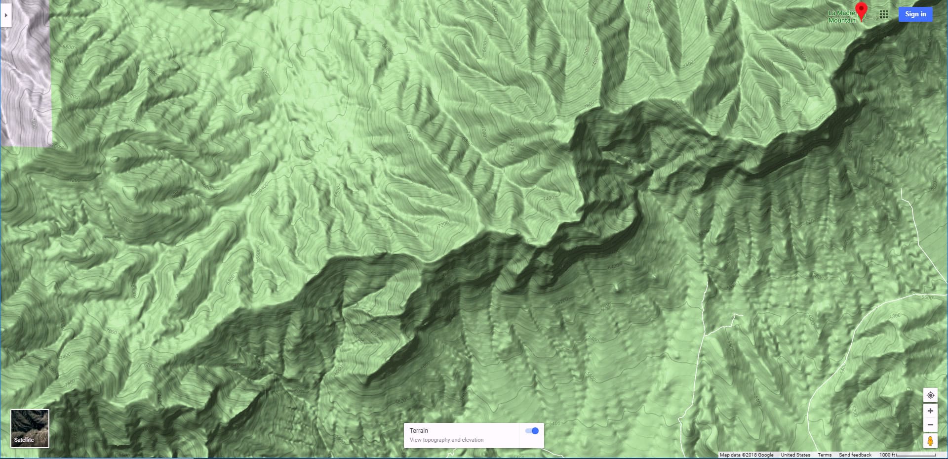
Where is El Bastardo Peak?
El Bastardo Peak is the high point on the cliff line you see at the upper end of Red Rock Canyon. That cliff line is the La Madre Mountains ridgeline which extends from above Lovell Canyon on the Western end to the edge of Las Vegas on the Eastern end. High points on the La Madre Ridgeline include:
El Bastardo Peak elevation 7,986ft: Positioned center/right on the La Madre Mountains ridgeline when viewed from Red Rock Canyon)
El Padre Peak elevation 8,093ft: Positioned central on the La Madre Mountains ridgeline when viewed from the Brownstone Basin (just East of Red Rock Canyon)
La Madre Peak elevation 8,154ft: Positioned just to the right of El Padre Peak on the La Madre Mountains ridgeline when viewed from the Brownstone Basin (just East of Red Rock Canyon)
So, you have the three high points: La Madre (The Mother), El Padre (The Father) and El Bastardo (The Bastard Child). Together, they form the highest points on the beautiful, remote La Madre Mountains Ridgeline, the high central ridgeline in the little-known La Madre Mountains Wilderness, 4 times the size of Red Rock Canyon and just West of Las Vegas. There’s a third high point on the ridgeline:
Burnt Peak elevation 7,900ft: Positioned just to the right of El Bastardo Peak, but harder to pick out due to its small size and clearance with the surrounding La Madre Ridgeline.
What’s Special About the La Madre Mountains Wilderness?
This huger wilderness area, closer to Las Vegas than the better-known Red Rock Canyon, is nonetheless wild and remote due to limited access. The high La Madre Ridgeline has no access trails and is very difficult to approach. It’s actually easier and faster to get to Death Valley! The vertical South side of the ridgeline has only one class 2 approach I know of, the rest being class 3 advanced rock scrambling and above. The more gradual North side of the ridgeline can only be accessed by a combination of 4WD vehicle roads and a long pathless wilderness traverse on foot.
The resulting remoteness of the La Madre Mountains Wilderness, far more untouched than Death Valley though right on the edge of Las Vegas, makes it wilderness wonderland. When you’re on the La Madre Mountains ridgeline, you may feel as if you’re thousands of miles away from civilization. Its high ponderosa pine and juniper forests are a sharp contrast to the arid desert just below.
The Views from El Bastardo Peak and the La Madre Mountains Ridgeline
As you’re ascending the La Madre Mountains Ridgeline, the dividing ridge positioned between Kyle Canyon to the North and Red Rock Canyon to the South, you’ll enjoy continually expansive views, eventually taking in a good 360-degree sweep of the Southern Nevada Wilderness and beyond. Points of reference include (short list):
To the West:
To the East:
To the North:
Adventure Route Summary
This adventure to El Bastardo Peak is a 17.5-mile loop adventure on foot with over 3,500ft elevation gain. The distance and elevation gain is similar to what you’d experience hiking the Mt. Charleston Loop Trail, with the added factor that half the adventure is through pathless wilderness. The entire route is a class 2 walk with a few brief class 3 rock scrambles on the La Madre Mountains Ridgeline.
The route begins at the Twilight Zone parking area (elevation about 4,500ft) at the intersection of Kyle Canyon and Harris Springs Roads. From there, take Harris Springs Road to the unmarked 4WD La Madre Mountain and Camping area access road. After ascending that road for about 2-3 miles, veer off into the wilderness to the right. Then take a wide canyon wash to the base of the long, gradual Western approach ridgeline to El Bastardo Peak. Once on the summit, turn East on the La Madre Ridgeline looping over to the neighboring Burnt Peak. Finally, take Burnt Peak’s descent ridgeline to the upper end of the La Madre Mountain access road, then retrace your way back to Kyle Canyon Road. You can cut off about half of the 17.5 mile hike with a 4WD vehicle.
Best Time of Year for This Adventure
Late Spring or Early Fall is best, when the temperature in Las Vegas is between 80 and 90 degrees. Summer can bring uncomfortably, even dangerous high heat along the lower route and Winter can bring snow and treacherous conditions on the upper route.
Directions to Starting Point | El Bastardo Peak | La Madre Mountains Wilderness, Nevada
Begin at the intersection of Kyle Canyon Road and Harris Springs Road. There is a parking area on the right side of Kyle Canyon Road just about 100 yards beyond where it intersects with Harris Springs Road. Head 3-4 miles up Harris Springs Road to where it intersects a 4wd road 3-4 miles North of the base of La Madre and El Padre Mountains. At the upper end of the 4WD road there is a turn-around loop. There is no marked trailhead, but your adventure begins here.
Narrative Guide | El Bastardo Peak | La Madre Mountains Wilderness, Nevada
Getting Your Bearings on the Target: El Bastardo Peak
At the Twilight Zone parking area, view the high La Madre Mountains Ridgeline to the South. La Madre Mountain with the huge limestone Devil’s Slide is most prominent on the ridgeline. To the right you can see Burnt Peak and a bit further to the right, your target, El Bastardo Peak. Looking carefully, you might be able to pick out three approach ridges to El Bastardo Peak: One on the left, one on the right and one in the center. I chose the longer, more gradual approach ridge on the right. You can also see a descent ridgeline from Burnt Peak (the peak to the left of El Bastardo). So now you’ve identified the two peaks on the La Madre Mountains Ridgeline and the access ridges to those peaks. This is important, because once you leave the road system, these reference points on the terrain will be your only guide.
Kyle Canyon Road, Harris Springs Road and the La Madre Mountain Approach Road to the Wilderness Departure Point
From the Twilight Zone parking area, head down Kyle Canyon Road about 500ft to take a right onto the entrance of Harris Springs Road. That road is wide and well graded for about 1,000ft where it takes a sharp right, heading West. Continue on Harris Springs Road for about 3 miles. The road continues to be well enough graded for a good 2WD vehicle. You’ll pass just one road branching off to the left in about a half mile. Continue West on Harris Springs Road for about 2.5 miles, watching for a narrow, unmarked, 4WD road branching off to the left. This is the La Madre Mountain approach road (see the map on this page for visible and GPS guided directions). Head up the 4WD La Madre Mountain access road for about 3 miles to the wilderness departure point.
As you’re heading up the La Madre Mountain access road, El Bastardo Peak and that long gradual approach ridgeline on the right side of the peak come into clearer focus. Also, note a wash winding through a narrow valley about 3-500ft to the right of the road. You’re going to veer off the La Madre Mountain Approach Road into the wilderness to the right, down into the wash and take the wash to the base of the El Bastardo approach ridge.
La Madre Mountain Approach Road to El Bastardo Peak Access Ridge
Where I left the La Madre Mountain Approach Road, the terrain to the wash is fairly level and open. There is a brief, sharp final descent into the wash, but it’s easy to find a nice descent point. Once in the wash, take a left and head up the wash. The wash is for the most part wide, gravelly and easy to traverse. There are a few short stretches where it’s a bit confusing to pick out the main wash, but just determine the main downhill route the water takes and you’ll again find yourself continuing in the main wash. A ridge to the right of the wash is a good guideline. Stay generally close to the base of that ridge as you ascend the wash. Try to keep perspective on your target El Bastardo approach ridge.
El Bastardo Peak Approach Ridge to the Summit
If you leave the wash before you reach the true base of the approach ridge things will be a bit more complicated as you’ll need to descend and ascend a few narrow gullies. Be patient, stay in the wash. A good sign you’re at the base of the approach ridge is when you’ve just passed the first limestone rock scramble in the wash. Watch for an access point to the ridge on your right, ascend from the wash onto the ridge (it’s a short, steep limestone slope). Then take a U-turn left onto the ridge. Now you’re weaving through a pine and juniper forest. Just stay on the center of the approach ridge. Now and then you’ll emerge from the forest to see the shape of the approach ridgeline ahead and the summit area. You want to stay on the ridge that approaches the right side of the summit. Actually, the true summit is above and beyond the summit area you can see from below on the ridgeline, so expect you’ll need to go a bit further to reach the true summit.
As you approach the false summit you begin to encounter some limestone rocky areas. In particular, there’s a long limestone ledge on the left side of the ridge. Keep that ledge to your left as you ascend. You may need to cross it a few times, but in general, keep it to your left. Once you reach the false summit, the incline becomes more gradual as it continues to the true summit, now visible. The summit of El Bastardo is actually a 2-300ft summit ridgeline. The highest summit area is on the right (West) end of the summit ridge. I arrived on the summit ridge a bit to the left of the highest summit area. It’s always a stunning moment to arrive on the ridgeline and see Red Rock Canyon, Brownstone Basin, the Calico Hills, Turtlehead Peak, the colorful Rainbow Mountains and Potosi Mountain suddenly come into view below! So that final short stretch to the West side of El Bastardo Summit is a magical victory walk! On this day there was a summit jar. It’s a rarely visited summit, so no elaborate summit box here. But the remoteness is part of the magic of El Bastardo Peak!
El Bastardo Peak to Burnt Peak
From the summit that has the jar, now turn East along the La Madre Mountains ridgeline. You’ll soon see the next high point to the East. That’s Burnt Peak. There’s a saddle between El Bastardo and Burnt Peak. Don’t be put off by the cliffy terrain between the two peaks. Just traverse near the summit of the ridgeline and at times not far below along the upper left (North) side of the ridgeline. I found a faint pathway here and there to help guide the way. There are a few limestone ledges to descend on the way to the ridgeline saddle. I found some fairly easy descent points taking me down and through the 20ft ledges with good hand and foot holds, like descending something between a stairway and a ladder, but no real exposure.
I made a big mistake when I arrived on the saddle between El Bastardo and Burnt Peak. As I’d already been to the summit of Burnt Peak a few times, I decided to take a shortcut to Burnt Peak’s descent ridgeline. Bad Bad!! What a horrible traverse! It would have been far easier to ascend to the summit of Burnt Peak before beginning to descend it’s approach ridgeline! Save yourself the pain I experienced and summit Burnt Peak before descending.
Burnt Peak to the Upper End of the La Madre Mountain Approach Road
The Burnt Peak descent ridge is actually a bit steeper with a few more light limestone rock scrambles than the El Bastardo approach ridge. But there’s always an easy class 3 or less way through the limestone areas. Just stay on the center of the ridgeline as you descend. Near the base of the ridgeline, the ridgeline splits. Take the right (North) split where, below, you will now be able to make out the upper end of the La Madre Mountain approach road. I’ve mistakenly taken the broader left split previously, requiring a traverse through an intervening gully and ascent back to the La Madre Mountain access road. Not a horrible mistake, but a bit time consuming and energy draining when you’re already tired.
Once you arrive on the La Madre Mountain approach road, just descend that road back to Harris Springs Road and ultimately, Kyle Canyon Road. Take time to note the beautiful campground at the upper end of the La Madre Mountain approach road. What a great place to spend a few nights. You could use that as a base to make a circuit of La Madre, El Padre, Burnt and El Bastardo Peaks all in one adventure. See this El Bastardo route plus my earlier La Madre, El Padre & Burnt Peak route for that potential adventure. In addition, just spending a night or two in this remote campground under the stars would be magical. In fact, I’d spend a night in the campground, hike La Madre & El Padre, spend a second night on El Padre under the stars with the lights of Las Vegas below, then the next morning hike to Burnt Peak, El Bastardo and back to the campground. Unforgettable experience!
Summary
You’ve just experienced a full day of incredible wilderness immersion! You’ve passed through yucca and cactus lands, ascended through beautiful juniper and pinyon pine forests with manzanita and ashy silk tassel shrubs. And experienced continually expansive views of a huge slice of Southern Nevada wilderness with distant views into California, Arizona and Utah lands. For much of this pathless wilderness adventure you may have felt as though you were the first human to tread on the remote ground upon which you are standing. Truly unforgettable!


