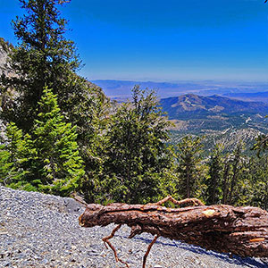
Overview | Deer Creek North Fork Canyon | Mt Charleston Wilderness, Nevada
The majestic ancient
Bristlecone Pines and sculpted
limestone formations create an incredible backdrop to the remote, pathless, rarely visited upper
Deer Creek North Fork Canyon. At the base of the canyon just above
Deer Creek Road is
Camp Stimpson. The canyon summit is the ridgeline between
Mummy’s Forehead to the North and
Mummy’s Chin to the South.
I’ve streamlined this approach over time, beginning at the
Deer Creek Catch Pen Trailhead at
Seven-Mile Canyon. From there, head up the East ridge of that canyon, then cross over to
Deer Creek North Fork Canyon to skirt the base of
Mummy’s Nose cliffs. Finally, land in the upper baseline wash of that canyon and circle its upper rim counterclockwise. In this video I identify the final summit approaches for both
Mummy’s Forehead and
Mummy’s Chin on the canyon’s upper ridgeline. I also identify an unrecorded airplane crash gully (see the linked page on
Las Vegas Area Trails for coordinates).
Spectacular Views Along the Way
This is a short list…the views are non-stop. You’ll feel as if you were on a mountaintop the entire way!
Additional Adventures in Deer Creek North Fork Canyon
Level of Difficulty
This entire route is class 3 and below (mostly walking along with a few light rock scrambles). However, there are steep loose rock slopes so watch your step!
Best Time of Year for This Adventure
A long Summer day is ideal. Even when it’s 110 degrees or above in the Las Vegas Valley, you’re in the comfortable 70’s in the upper canyon. On the other hand, Winter can bring snow and ice making the steep slopes dangerous.
Directions to Start Point | Deer Creek North Fork Canyon | Mt Charleston Wilderness, Nevada
To get to the trailhead from Las Vegas head North on
Hwy-95 taking a left at one of the last
Hwy-95 exits in the
Las Vegas area,
Kyle Canyon exit. Continue up
Kyle Canyon Road about 17 miles and a couple miles before
Charleston Village take a right on
Highway 158 toward
Lee Canyon. You’ll wind around the hillside to the left and as the road briefly levels off before descending toward
Lee Canyon. Pass the
North Loop Trailhead,
Deer Creek Picnic Area and the
Camp Stimpson turnoff. The trailhead is a small parking area on the right just before the
Desert View Overlook parking area. It’s the trailhead parking for the
Deer Creek Catch Pen Loop Trail.
↓ Narrative Guide ↓
Narrative Guide | Deer Creek North Fork Canyon | Mt Charleston Wilderness, Nevada
Getting Your Initial Bearings
That large pointed limestone cliff you see above the Deer Creek Catch Pen Trailhead is
Mummy’s Nose. The area between
Mummy’s Nose and the trailhead is
Seven-Mile Canyon.
Seven-Mile Canyon is bordered by a ridgeline on either side: Eastern Ridge to the left and Western Ridge to the right. You’re going to ascend the Eastern ridge, circle the left base of
Mummy’s Nose, then ascend to
Mummy’s Forehead, hidden behind the
Mummy’s Nose. The Western ridgeline of
Seven-Mile Canyon is the better approach to summit
Mummy’s Nose.
Deer Creek Catch Pen Trailhead to Base of Mummy’s Nose
From the trailhead, cross Deer Creek Road and take the unmarked
Forest Road 092A on the opposite side toward
Mummy’s Nose skirting the base of the canyon’s Eastern ridgeline. Soon there will be a fork in the road with 092 “
Seven-Mile Canyon Road” splitting off the the right. Keep to the left. You want to get to the summit of that Eastern ridgeline and your choices are sooner or later:
- Sooner: This is the best view route, but takes longer. Take a left onto the first ridgeline ascent gully after the fork in the road (see the video). You’ll soon ascend to spectacular views!
- Later: Continue on Road 092 until it ends, then take a left onto the Eastern ridgeline above. This gets you to the upper ridgeline faster (I video-document this option on the return descent).
If you take the longer view route (sooner ascent, #1 above), ascend the fairly gradual gully, then angle to the right along the upper ridgeline. Once on the ridgeline you can immediately see
Mummy’s main summit,
Mummy’s Knees and Toe,
Bristlecone Pine Ridge, the
La Madre Mountains,
Angel Peak,
Gass Peak, the
Sheep Range, and most prominently,
Mummy’s Nose. You can also see where the ridgeline connects with
Mummy’s Nose and the beginning of your route along the base of the Eastern cliffs. In addition, this route lands you more quickly in a beautiful
bristlecone pine forest. The Eastern ridgeline is worth a short trip in itself, just to quickly ascend to the pines and the views!
There are about three distinctive high points along the Eastern ridgeline, each offering a more spectacular surrounding view than the one before!
At about 9,000ft elevation, you’ll reach a beautiful pointed limestone pillar on the ridgeline. Continue up the ridgeline another 470ft elevation, then turn left off the ridgeline and along the base of Mummy’s Nose cliffs. This is what I call the
“Goldilocks Sweet Spot Elevation” for traversing the base of
Mummy’s Nose cliffs. A lower elevation would cause you to get bogged down ascending and descending intervening gullies and ridges. A higher elevation would put you on very steep, difficult slopes.
If you took the quicker route and summited the Eastern Ridgeline just above the upper end of
Road 092A, you’d arrive on the ridgeline just below the
limestone pillar.
Mummy’s Nose Cliffs to Deer Creek North Fork Gully
Another great advantage to the 9,470ft elevation route is that you can hold that same elevation all the way to the
Deer Creek North Fork Gully. Along the way you’ll cross intervening 4 gullies an ridges, pretty shallow at this elevation. The 4th gully is where I came across debris of an
undocumented plane crash, possibly from the 1990’s. The ridgeline preceding that 4th gully might be a good ascent route to possibly view the main section of the plane.
Continue along the long, fairly level ridge that follows the 4th gully until your 9,470ft elevation route lands you in the Deer Creek North Fork Gully.
Here are the coordinates for the upper plane crash gully:
11S PA 21841 20282
36.31986, -115.64266
9701ft WGS84
Ascend the gully and engage in some steep rock scrambling to potentially locate fuselage. Descend to locate engine, wheels and other debris.
Deer Creek North Fork Gully to the Dry Fall Bypass
The great thing about this route is that it lands you in the ascent gully at the same altitude you’ve been traversing along the
Mummy’s Nose Eastern Cliffs (9,470ft), thus avoiding additional ascent/descent inclines and conserving your energy for the next stretch. Now you’re in a beautiful pine forested gully, but with a lot of brush, trees and boulders to navigate. For this next stretch, watch for a couple early bypass routes above the gully to the left that will save you navigating the brush and boulders in the baseline gully.
The second bypass will descend into the gully again. This is where you cross the gully to a bypass above on the right side. Continue on this bypass for about 50 yards until you’re confronted with a choice of descending into the gully again or taking the slope upward to the right. If you descend into the gully again, you’ll soon need to take the slope upward to the right as there’s a barrier dry fall not to far ahead in the main gully. Notice a rocky ridge ascending perpendicular above the gully. Skirting the near base of this ridge, up and over, will bypass the gully’s barrier dry fall.
Dry Fall Bypass to the Northern Cliff Base
Once you’ve rounded the rocky ridge you have another choice. The more streamlined route is to descend again into the main gully and ascend that gully upward until it forks to the left and right near the canyon summit. In the video, I took the other choice which is to continue up the slope above the right side of the gully all the way to the base of the canyon’s Northern cliffs. I wanted to explore the upper North end of the gully and search for an approach to Mummy’s Forehead. My choice resulted in a lot of steep slope traversing which incidentally, did not take me very far above the baseline gully. Every time I crossed an intervening ridge, there was the baseline gully only around 30ft below me! Much less work just to stay in the baseline gully until the upper fork!
However, I did reach a point where I found myself in the upper right fork of the canyon wash, continuing up to the base of the Northern cliffs above. What a lot of extra work, but it was a learning experience! Steep steep slope!! The ascent became a little less drastic at the base of the cliffs where there was a narrow pathway continuing upward along the cliff base. Here were the most beautiful bristlecone pines in the canyon! That pathway was fun!
Northern Cliff Base and Across the Upper End of the Canyon
As the cliff base pathway began to circle to the left across the upper end of the canyon, around 50ft or less below the upper saddle, there was what looked like a steep approach to
Mummy’s Forehead on the upper left end of the canyon.
Mummy’s Forehead was only around 100 vertical feet above. The steep approach was a series of ledges–huge steps–with loose rock surface. It looked like climbers had used this route frequently.
At this same point, at the left turn across the canyon’s upper ridgeline saddle between
Mummy’s Forehead on the right and
Mummy’s Chin on the left, there was a nice pathway–a regular trail with cairns. This trail skirted the upper saddle just about 50 vertical feet below the saddle’s rocky upper ridgeline. When I return, my goal is to take that upper rocky ridgeline between
Mummy’s Forehead and
Mummy’s Chin, summiting them both.
Today I ended up at a small upper plateau near the center of the canyon’s upper saddle. From there, it looked like the route to
Mummy’s Chin might be fairly easy, less than a half-mile. Future adventure!
Return from Upper Saddle to Deer Creek Road
From the center of the upper saddle, angle downward toward the main gully. Stay fairly high as you angle downward. If you descend too far the terrain gets much steeper. You’ll find the sweet spot where the terrain is not too steep.
I headed downward in the main gully, then crossed it to descend on the slope above the North (left) side of the gully realizing that there was a barrier dry fall below in the main gully. I stayed above on the left side of the gully until I crossed that perpendicular rock formation I knew was below the dry fall. Then, I descended toward the main gully and took the lower bypass routes first on the left, then on the right, finally ending up in the spot where I had landed in the gully during the original ascent from
Deer Creek Road. Then it was just a matter of traversing the slopes below the
Mummy’s Nose cliffs at an altitude of about 9,500ft until reaching the
limestone pillar on the Eastern ridgeline of
Seven-Mile Canyon.
Not far below the
limestone pillar on the Eastern ridgeline, you’ll reach a very small cairn I created marking the point where you descend the faint pathway to the left and toward the upper end of
Forest Road 092A in
Seven-Mile Canyon. The pathway is faint and you may lose it, but just angle down into
Seven-Mile Canyon and you’ll come across the upper end of
Forest Road 092A (see the video where I document the cairn where the faint pathway meets the road). Now, take a right onto the road and descend to your starting point at the
Deer Creek Catch Pen Trailhead on
Deer Creek Road!
Conclusion
Congratulations! You’ve traversed the remote, seldom visited
Deer Creek North Fork Canyon. Along the way you’ve passed through majestic ancient
bristlecone pine forests, crossed a gully with debris from an
unrecorded plane crash from the 1990s, and ascended to discover the final summit approaches for
Mummy’s Forehead and
Mummy’s Chin on the upper rim of
Deer Creek North Fork Canyon! That’s quite the memorable accomplishment!