Overview | Damsel Peak Southeastern Pinnacle Loop | La Madre Mountains Wilderness, Nevada
Scopping Out a Damsel Peak End-to-End Adventure
Okay, I intended this to be the Damsel Peak End-to-End adventure including the SE Pinnacle, SE Summit and NW Summit. However, we got cliffed out at the SE Pinnacle. Still, the observation point at the outer edge of the massive SE Pinnacle cliff was spectacular. And, I worked out a streamlined approach up the SE Slope that should speed up the approach giving more time to work out the route to traverse the 2 summits. In addition, it’s clear now that the route from the SE Pinnacle to the SE Summit requires circling around the lower end of the Pinnacle and then continuing upward. I’ll test that out soon.
Route Summary
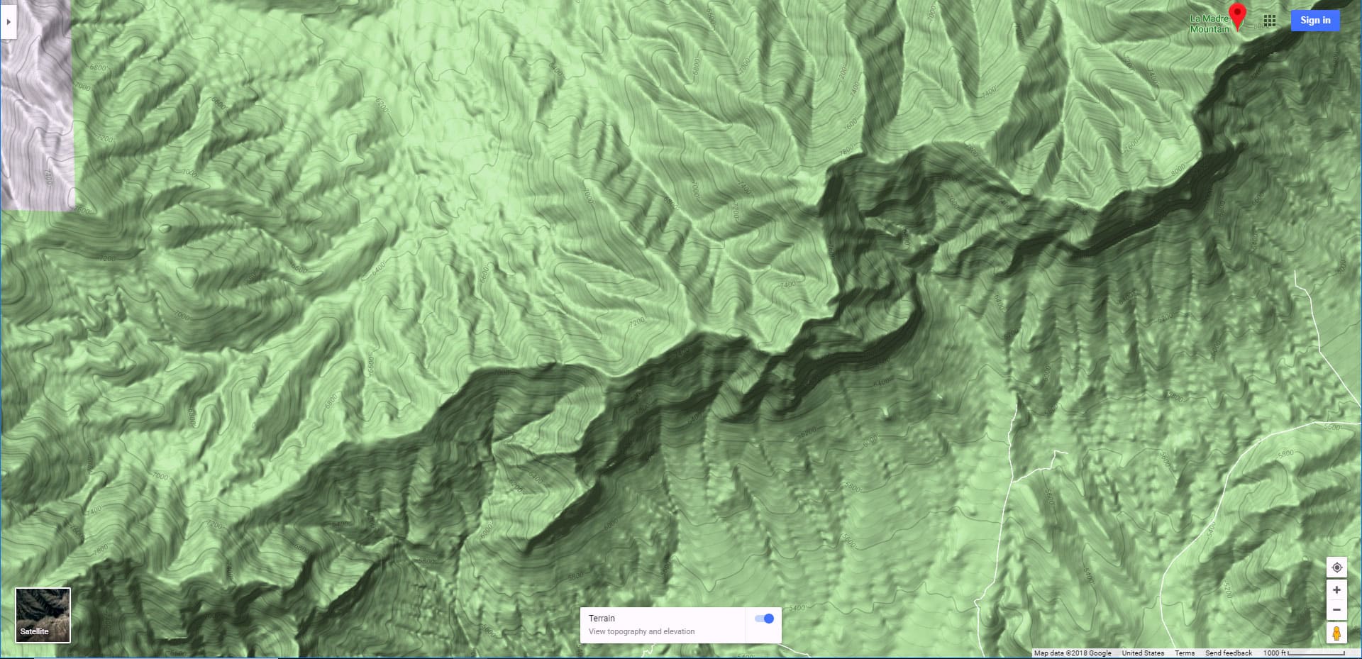
The route we took begins at the upper end of Far Hills Ave. From there, cross the desert terrain of ridgelines and gullies to the Southeast Slope of the Southeast Canyon on Damsel Peak. Ascend the left (South) edge of the Southeast Canyon to the Southeast Pinnacle. The return down the more gentle Southeast Slope. As the lower part of this route involves passing through residential construction and private property, an alternate, but longer approach beginning at Gene’s Trailhead in the Calico Basin entirely bypasses private property. See the map on this page.
This Southeast Pinnacle Loop is Incredible
In the meantime, the Southeast Pinnacle Loop is in itself an incredible adventure! The terrain up the SE Canyon is beautiful. Between the scattered bonsai-like pines, yuccas, creasote and other plants, and the massive limestone plates it’s the feel of being in another world. You could never imagine such a beautiful terrain viewing it from below. And though the Southeast Pinnacle looks like a small spire from below, when you’re there, it’s a massive limestone cliff sharply standing out from its surroundings.
The Geology of the Terrain
Those massive limestone plates I mentioned, that line the SE slope of Damsel Peak and, in particular the South side of the huge Southeast canyon, are actually frozen mud from an ancient sea bed. The mud was infused with calcium from the sea creatures that died and drifted to the bottom. Once frozen into a massive plate the geological forces of plate tectonics subduction lifted the plates into 45-degree angles. The long, grayish ledges you see today stand out beautifully in the desert environment. As you ascend, you’re in the midst of geological history!
The Spectacular Views
As you rapidly ascend, keeping your focus on firmly planting the next step and charting your forward course through the limestone ledges along the way, take a moment now and then to turn around. You’ll be surprised at how massive the gaping canyon below has become. From the Southeast Pinnacle Observation Point you can see (clockwise direction):
This is a short list, there’s a lot more!
Best Time of Year for The Southeast Pinnacle Loop
Stick to Fall through Spring. Summer months can bring temperatures exceeding 100 degrees. Watch out for slick snow and ice in the Winter months which can make navigation on the slopes and ledges treacherous.
Route Starting Point Directions | Damsel Peak Southeastern Pinnacle Loop | La Madre Mountains Wilderness, Nevada
From Las Vegas, take Hwy 95 North, then Summerlin Parkway, then I-215 South to the Far Hills Ave exit. Take a right onto Far Hills Ave. and continue to where the street ends. Note: There is residential construction in the area and potentially no parking, so you may need to be dropped off.
As an alternative, see the route that begins at Gene’s Trailhead in the Calico Basin. It’s a longer approach route, but the parking is secure and you will not need to pass through private property or construction.
Narrative Guide | Damsel Peak Southeastern Pinnacle Loop | La Madre Mountains Wilderness, Nevada
We started at the upper end of Far Hills Ave. in Summerlin. Due to the construction and lack of secure parking, we were dropped off.
Getting Your Bearings
Even if you’re familiar with the look of Damsel Peak, it’s hard to pick out from the angle where you are standing on Far Hills Ave. The Southeast Pinnacle, though in plain sight, disappears in the SE Summit’s background. The Northwest Summit is hidden. I wasn’t sure the hill we were viewing was actually Damsel Peak. If you were to draw a long line continuing from the end of Far Hills Ave., that large hill ahead is indeed Damsel Peak. Note a large canyon on the left side of that hill. That’s the Southeast Canyon and the Southeast Slope is the canyon’s left side. Your initial target is the gully at the base of the canyon.
Far Hills Avenue to the Southeast Canyon
As you head for the Southeast Canyon, you’ll need to traverse a few low ridgelines and shallow gully washes along the way. While standing on a ridgeline where you can get a good view of the terrain, identify the ridgeline that leads to the base of the Southeast Canyon. Head for that ridgeline and take it to the Southeast Canyon. I call this “Toyota Ridge” as there’s a red Toyota pick-up on the ridge that met a tragic demise, with the cab about 150ft from the pick-up bed!
Southeast Canyon to the Southeast Pinnacle
The Southeast Canyon wash is pretty rugged with huge boulders and lots of sharp plants (yucca spikes…etc.). So, you may want to set a course above the base of the gully. Our course at first skirted the terrain just above the right side of the gully, then crossed the gully to begin an ascent toward the Southeast Pinnacle. Note a long low ridgeline cliff (actually 30ft or more in height when you get there) angling down the left side of the canyon. We circled around the lower edge of the ridgeline cliff before taking a sharper upward ascent. By this time you can easily pick out the beautiful Southeast Pinnacle cliff. Make that your target.
We aimed for the left (outer) side of the Pinnacle, eventually ascending to the spectacular observation point at the outer edge. It was clear that continuing beyond that point would have meant navigating a vertical El Capitan-type cliff, so we knew we were at the high point of this surprisingly beautiful adventure. It was also clear that to continue up to the Southeast Summit of Damsel Peak would have required we circle around the lower right edge of the Southeast Pinnacle. Still, we were at about 6,500ft, just about 500ft below the Southeast Summit. That’s another adventure.
Looping Down the Southeast Ridgeline
For the return trip, we looped down the outer edge of the Southeast Ridgeline. There were two or three distinctive ledges to descend along the way. I found it easy to traverse the upper edge of each ledge until I eventually found a nice descent gully that would take me down to the next level. Overall, the ridgeline descent was far more gradual and stable than the canyon wall ascent we’d made on the approach. Once at the base of the Southeast Slope it was just a matter of navigating the low ridgelines and gullies, retracing our way back to the upper edge of Far Hills Ave. While descending along one of the low ridges we saw a white pick-up truck, security vehicle on a neighboring ridge slowly tracing our descent. We were on Howard Hughes private property. He lost interest when he eventually reassured himself we were just passing through.
Conclusion
Though this adventure is not the larger Damsel Peak End-to-End adventure, it’s a cool adventure in its own right. It’s shorter, but the views and the terrain are second to none! My suggestion is to be at the Southeast Pinnacle observation point a couple hours before sunset. The Las Vegas Valley, Strip and views beyond will stand out in brilliant sharp definition at that time, beautifully lit up in the evening sunlight. And, you should have time to descend the Southeast Slope in the light (give yourself a couple hours daylight to get down off the slope)!


