Overview | Sawmill Loop Trail | Sawmill Trailhead | Lee Canyon, Nevada
Hub for the Sawmill Trail Network
The Sawmill Loop, though just 1.5 miles, is one of the most important trails in the 6-loop Sawmill Trail network. It’s the key to understanding how to navigate this beautiful but sometimes confusing network of trails. Most of the links to the other 6 loops in the Sawmill Trail Network can be found on the Sawmill Loop, and that’s where the color-coded intersections are most confusing. If you “get” the intersections off the Sawmill Trail correctly, you’re more likely to successfully navigate the entire trail network. If you do not “get” the intersections correctly, you may end up failing to find and hike the longer loops.
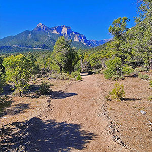
Great Sample of the Beautiful Sawmill Loops Terrain
The Sawmill Loop Trails span a large swath of the beautiful Eastern slopes of the Spring Mountains. In contrast to the stark desert regions below and the open ridgelines and peaks above, this swath is an oasis of shaded pine and juniper forests along with a huge variety of additional vegetation including currents, mountain mahogany, oak, yucca, cacti and much more. And the surrounding vistas of majestic limestone peaks, ridgelines and vast desert terrain are spectacular.
Navigate the Sawmill Loop First
Navigate the Sawmill Loop first. Identify each intersection. Take a copy of the map along with you so you can understand where each one goes. Identify the surrounding reference points of peaks and ridges. Then you’re in a better position to navigate the other loop trails.
Color Coded Trail System
Here are the 6 loop trails in the Sawmill Trail Network and their color codes (see the map on the main page):
- Sawmill Loop – Light Yellow
- Mud Springs Loop – Green
- Pinyon Pine Loop – Red
- Blue Tree Loop – Blue
- Rocky Gap Loop – Light Brown
- Deer Creek Catch Pen Loop – Dark Yellow
Here’s what can be confusing: To find some of the outer loops (especially Green, Red, Light Brown, Dark Yellow), you’ll need to follow a different color. For example, to get to the green loop, you need to follow red; to get to the light brown loop you’ll need to follow red and blue. Once you’re on the longer, outer loops, there are fewer intersections or off-branching pathways. But when you come across an intersection on the outer loops, it’s likely to have no directional sign. At these questionable intersections, you’re left guessing which branch to take in order to remain on the trail.
Bomb-Proof Directional Strategy
Fortunately, the surrounding peaks, ridges and vast desert regions below are stable, bomb-proof directional indicators. For example, Mummy’s Head, the best directional indicator, is visible much of the time from the Sawmill Loop and from the longer outer loops. You’re not likely to stray off course on the easy Sawmill Loop. But if you stray off course on one of the outer loops, just head for Mummy’s Head. By doing so, you’ll eventually reach Lee Canyon Road within a quarter-mile of the trailhead.
Note the high ridgeline to the South of the Sawmill Loop. On the opposite side of this ridgeline are the Sisters Peaks (Black Rock, North and South Sister), the 15-mile Mud Springs Loop and the nine-mile Pinyon Pine Loop. Closer to Lee Canyon Road, and spanning the terrain above the lower desert are the Blue Tree and Rocky Gap Loops. Further away, along the Eastern slopes of Mummy’s Head is the Deer Creek Catch-Pen Loop.
Note the vast desert terrain below to the East with a backdrop of the Sheep Range, Gass Peak and the Hwy 95 corridor stretching to the North. With all these reference points, identifiable from the Sawmill Loop, you have a directional indicator you can always depend on! Trail markers and color-coded signs may fail, but the surrounding reference points are bomb-proof, dependable markers.
Best Time of Year to Hike the Sawmill Loop
The average altitude of the trails in the Sawmill Loop Network is about 7,000ft. Knowing that with each 1,000ft elevation gain you lose about 5 degrees temperature, it’s easy to do the math and predict the temperature you will be experiencing based on the temperature in Las Vegas (around 2,000ft elevation). Mid Summer temperatures on trails in the Sawmill Loop Network can reach a dangerous 100 degrees. Mid Winter temperatures can drop to 20 degrees and below. Spring and Fall are the sweet spot for hiking the Sawmill Loop.
Trailhead Directions | Sawmill Loop Trail | Sawmill Trailhead | Lee Canyon, Nevada
Take Hwy 95 North from Las Vegas and take a left at the Lee Canyon Road exit (Hwy 156). Travel up Lee Canyon Road about 13 miles. Take a right onto the Sawmill Trailhead Access Road and proceed to the trailhead. Stay left to reach the upper trailhead parking area.
Narrative Guide | Sawmill Loop Trail | Sawmill Trailhead | Lee Canyon, Nevada
There are two main trailheads for the Sawmill Network: The upper hikers/picnicker trailhead and the lower equestrian trailhead. Both are accessed from the same intersection off Lee Canyon Road. I access the Sawmill Loops from the upper trailhead by the main, well-marked entrance trail opposite the restroom there. The trail’s light yellow color code is a dependable indicator on the markers throughout, so you are unlikely to stray off course on the Sawmill Loop. Just keep to the yellow and, if going clockwise on the loop, keep to your right. But notice each intersection in order to identify how you will access the other loops in the system.
Trail Intersections
Here are the trail intersections to note along this quick 1.5-mile loop:
- Clockwise/Counterclockwise Loop Beginning and End Intersection: The loop begins and ends at the intersection around 100ft from the main trailhead.
- 1st Mud Springs (Green) and Pinyon Pine (Red) Intersection: This is less than a mile in. You’ll only see a red-colored indicator and need to trust that you follow the red to get to the green. Both the clockwise and counterclockwise loop entrances for the Mud Springs Loop are accessed from this intersection along with the clockwise Pinyon Pine loop direction.
- Blue Tree (Blue), Pinyon Pine (Red), Mud Springs (Green), Rocky Gap (Light Brown): A little over a mile in you’ll reach this intersection, which has 2 off-branching pathways. Due to all the colors needed, this is probably the most confusing intersection. You’ll see Blue and Red, but no Green, except for a little tape that was later placed on the marker posts. There is no light brown to be seen. In short, you need to study the map and know which colors this intersection accesses.
- Blue Tree (Blue), Equestrian Trailhead, Deer Creek Catch-Pen (Dark Yellow): The blue us clearly marked. There is not indication that you can reach the dark yellow from this intersection.
Conclusion and Equestrian Note
Having put so much emphasis recognizing directional markers, colors and reference points in the terrain, take time to put all this navigational planning aside to enjoy the beautiful setting you are in as you traverse the Sawmill Loop. It’s a small sample of the wonders you will experience on the larger loops in this network of awesome trails!
The Sawmill Loop is the main route used by organizations offering equestrian adventures (see the video on this page). The equestrian trailhead is well-equipped. There is ample parking for trailers, hitching posts, watering spots and a corral. But you’ll need to bring food and water for your horses. There’s no piped-in water.