Wildrose Peak | Death Valley, California
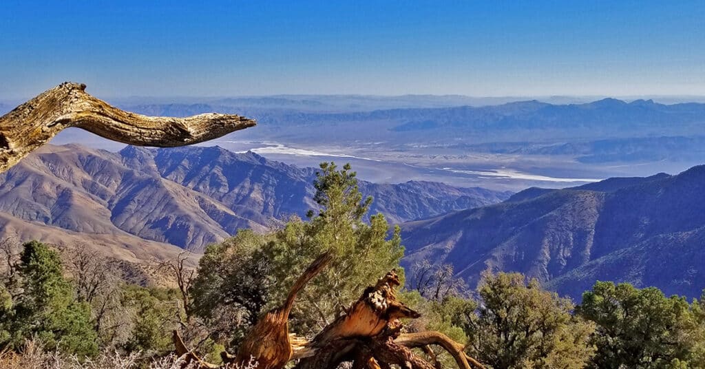
Wildrose Peak is an 8.4 mile round trip trail beginning at the Wildrose Charcoal Kilns in Death Valley National Park, California. Ascending the excellent trail from the Wildrose Charcoal Kilns at 6,800ft elevation to the summit of Wildrose Peak at 9,064ft elevation, your total elevation gain is 2,264ft. Views at points along the trail and definitely from the summit are spectacular including the expanse of Death Valley almost directly below from Badwater to Furnace Creek and further in both directions with the Funeral Mountains as a backdrop. It’s a Grand Canyon level view! 8.4 Miles RT, 6,800 > 9,064ft **Excellent Trail** Click image or title above for more…
Wildrose Charcoal Kilns | Death Valley, California
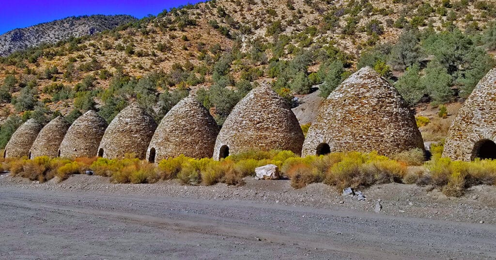
The Death Valley Wildrose Charcoal Kilns, located on Charcoal Kiln Road near Telescope Peak in the Panamint Mountain Range are perhaps the best preserved Charcoal Kilns on earth. Built in 1877 to create charcoal used to smelt lead and silver in the Modock Mines about 25 miles West in the Argus Range, the Wildrose Charcoal Kilns were only used for 2 years. Click image or title above for more…
Telescope Peak Summit from Charcoal Kilns | Death Valley, California
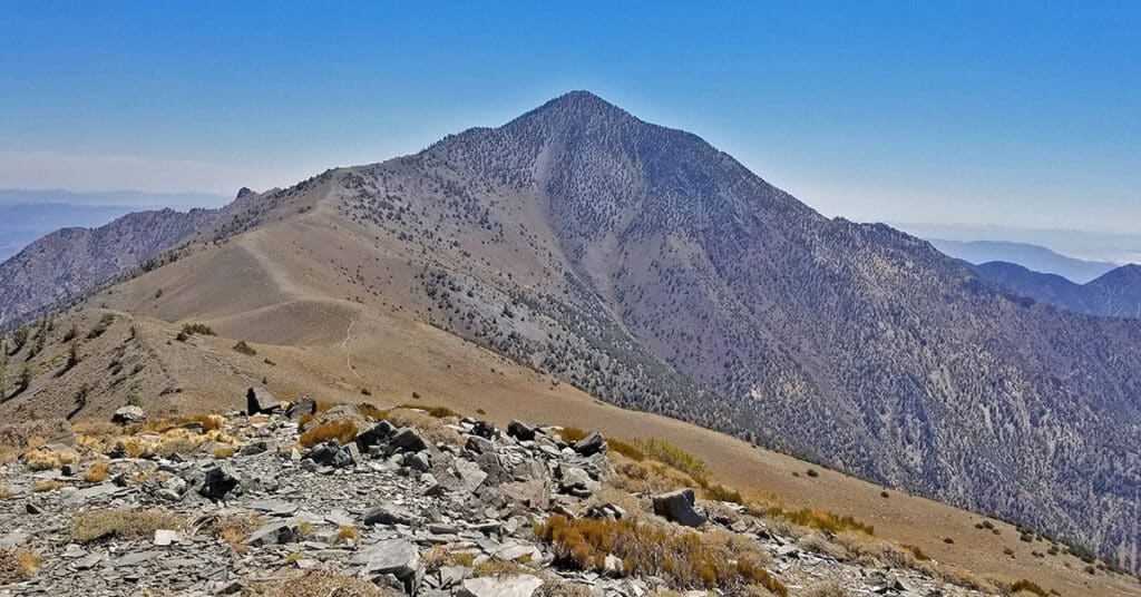
Telescope Peak, on the highest ridge of the Panamint Mountain Range bordering the West side of Death Valley is as close as you can get to experiencing the entire valley in one adventure. The feeling is purely magical as you traverse a ridge on top of the world, looking straight from that 11,049ft elevation down to Badwater, lowest point in the Western hemisphere at -282ft. Route details: 19 mi Roads, Trails (mostly), Wilderness
6800ft > 11,043ft **Mostly Excellent Trails** Click image or title above for more…
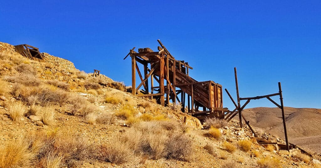
Skidoo Ghost Town | Death Valley National Park, California
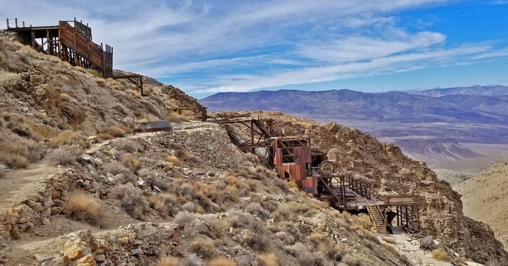
Skidoo Ghost Town & Mill, located near Emigrant Canyon in the Panamint mountain range above Death Valley, California, is an old California gold rush ghost town approachable by 4WD vehicles on a 9-mile unpaved road. The hills around Skidoo Ghost Town & Mill have around 1,000 abandoned mines along with the remains of iron machinery, wooden cabins, old rusting cars and other odds and ends from the mining era. The largest, most impressive remaining structure is the Skidoo Stamp Mill used to extract gold from raw ore. Route details: 18 Miles RT; 5000 > 5700ft **Fair Unpaved Road** Click image or title above for more…
Mesquite Dunes at Sunrise | Death Valley National Park, California
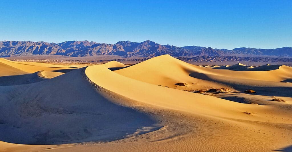
The Mesquite Sand Dunes turn every shade of color from white to golden during the hours of sunrise and sunset. But to witness the best display, you’ll need to wander into or out of the midst of the Mesquite Dunes in the dark, either before sunrise or after sunset. And during the time of pitch darkness, you’re either going to risk meeting up with a sidewinder rattlesnake during the warmer months from mid Spring through mid Fall, or getting very cold during the colder months from mid Fall through mid Spring. Route Details: Approx. 1.5 Miles RT; 100 – 200ft Elevation Gain **Wander Among the Dunes** Click image or title above for more…
Mosaic Canyon | Death Valley National Park, California
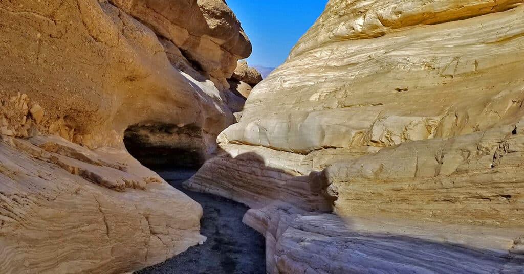
Though Mosaic Canyon is not a true slot canyon, there are some similarities. The action of water over tens of thousands of years has cut through and polished the solid rock walls into a surface resembling fine marble. Scenes of polished rock recall images of what you’d like to see in the ultimate elaborate marble bathroom or natural swimming pool. In places, there are large polished walls of composite rock forming countless wonderful unique mosaic patterns. Route details: Approx. 2-4 Miles RT; Approx. 900 > 2,000ft **Good Canyon Trail** Click image or title above for more…
Eureka Mine | Harrisburg (Aguereberry Camp) | Cashier Mill | Death Valley, California
Eureka Mine and its supporting mining town, Harrisburg (Aguereberry Camp) and Cashier Mill were founded by Pete Aguereberry and Shorty Harris in 1905. Cashier Mill, built in 1909, utilized gas power to extract gold from the ore hauled from Eureka Mine, first pulverizing the ore, then using mercury and cyanide to extract the gold. Route Details: Turn left off of Emigrant Canyon Road onto Aguereberry Point Road. Eureka Mine along with Pete Aguereberry’s Cabin and the Cashier Mill are less than a mile up the road on the right. Click image or title above for more…
Darwin Falls | Death Valley National Park, California
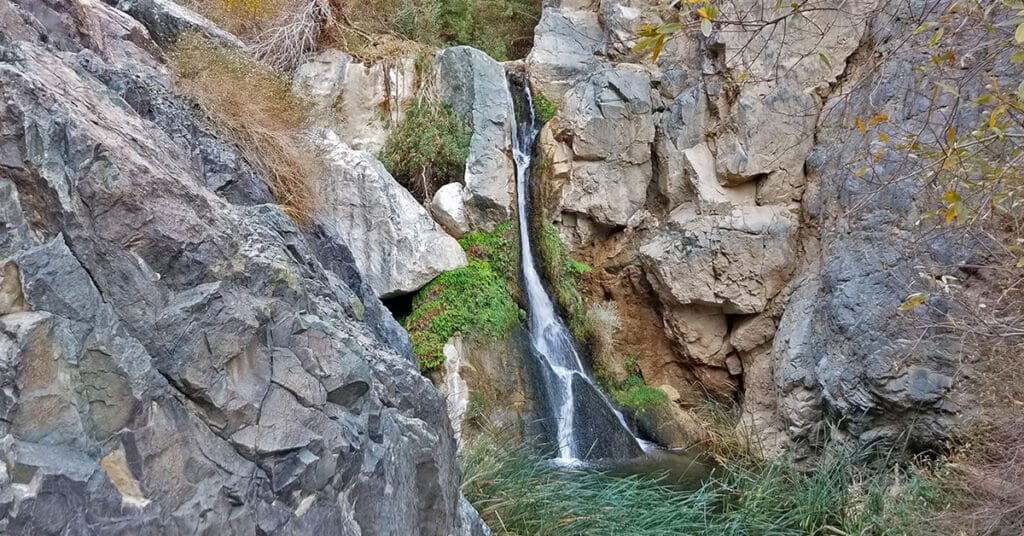
Darwin Falls oasis is fed by a spring so powerful that it cascades as a large waterfall 80 feet down a cliff face year-round, giving rise to a seemingly unique and isolated tropical community of birds, frogs, reeds, ferns and trees surrounding the large pond at the base of the falls. The stream and the unique life zone then meanders along another quarter mile creating a few smaller singing waterfalls before finally disappearing into the floor of the arid desert canyon below. 2-Mile RT; approx. 2500 > 2700ft **Good Trail, Sketchy Near Falls** Click image or title above for more…
Aguereberry Point | Death Valley, California
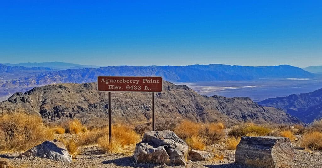
At 6,433ft elevation Aguereberry Point sits on the West side of Death Valley in the Panamint Mountain Range. It’s nearly opposite to the more popular 5,575ft Dante’s View on the East side of Death Valley in the Funeral Mountains above Badwater. Aguereberry Point offers spectacular views the total length up and down Death Valley! Route details: Approx. 12 Miles RT; 4,800 > 6,433ft; **Unpaved Road 2WD When Freshly Graded** Click image or title above for more…
Willow Canyon | Death Valley National Park, California
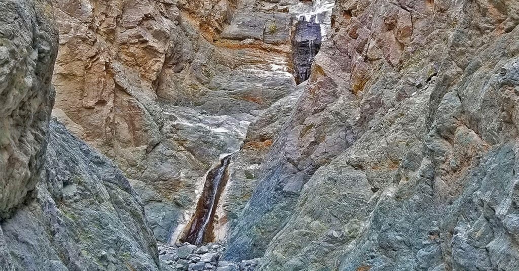
Willow Canyon along with Darwin Falls are both rare year-round waterfalls in Death Valley, one of the hottest, driest places on earth! Often missed, Willow Canyon shares the same trailhead with the more popular Sidewinder Canyon. The most beautiful part of Willow Canyon is the last 1/4th mile of this 2-mile adventure before the falls where the canyon narrows, the water begins to flow and cascade over rocks and the surrounding cliffs reveal amazing sculptures. Route details: Approx. 4 Miles Out and Back; 500ft Elevation Gain **Canyon Wash Route** Click image or title above for more…