Overview – Wilson Ridge/ Sexton Ridge Circuit | Lovell Canyon, Nevada
This is a 2-day wilderness immersion adventure with spectacular views of upper Lovell Canyon from its surrounding ridgelines: Wilson Ridge, Harris/Griffith Saddle and Sexton Ridge. Spend the night on Harris Mountain summit.
The Adventure Route Overview
The adventure route begins at the parking area on the upper end of Lovell Canyon Road, across from the Torino Ranch/Children’s Camp. From there take Lovell Canyon Trail to the base of Lovell Canyon. Then, ascend the Wilson Ridge, summiting that ridge about 1/2 mile Northwest of the Wilson Ridge Southern High Point.
Continue up the Wilson Ridge to its intersection with Harris Mountain Road. Cross Harris Mountain Road and continue up the Wilson Ridge to Harris Mountain Summit. Spend the night on that beautiful remote summit with sunset to sunrise views over the Las Vegas Valley.
Descend Harris Mountain Summit to the Harris/Griffith saddle and connect with the Griffith Peak Wilderness Trail. Take the Griffith Peak Wilderness Trail to Griffith Peak Summit. Then descend from Griffith Peak Summit via Sexton Ridge to connect with the upper end of the Griffith Shadow Loop Trail. Finally, descend the Griffith Shadow Loop Trail to connect with the Lovell Canyon Trail and return to the start point at the parking area across from the Torino Ranch/Children’s Camp.
Benefits of This Adventure Route
You will experience a unique and spectacular eagle-eye perspective of Lovell Canyon from its highest East, North and West ridgelines: Wilson Ridge (East); Griffith/Harris Saddle (North) and Sexton Ridge (West). In addition, you’ll see the entire length of neighboring Kyle Canyon and Harris Springs Canyon from the La Madre Mountains on the lower East end to Charleston Peak on the upper West end. You’ll also see the entire length of neighboring Trout Canyon. And, of course, the entire length of upper Lovell Canyon from the upper end of Lovell Canyon Road to the upper end of the canyon at the Griffith/Harris Saddle.
Route Strategy
The counterclockwise loop direction is designed to end with a total down-hill experience from Griffith Peak to the end point during the time it’s expected that you will be most tired and just wanting to coast back to your vehicle!
Best Time of Year for This Adventure
Stick to the longest days of mid-Summer in order to maximize daylight on this long 2-day adventure, and warmth during the night on Harris Mountain summit.
Trailhead Directions – Wilson Ridge/ Sexton Ridge Circuit | Lovell Canyon, Nevada
Take Hwy 160 from Las Vegas toward Pahrump. The highway ascends over a “hump” (the Potosi Mountain area). There’s a saying around here, “Over the hump to Pahrump”. Well, you’ve just traveled over that hump. Around 4-5 miles from the point where the highway begins to descend toward Pahrump there is a well-marked sign on the right for Lovell Canyon Road.
Views Along Lovell Canyon Road
Lovell Canyon Road is a beautiful stretch passing through a Joshua Tree forest that soon becomes populated predominately with junipers and pines. There are ridges and meadows and many camping pull-outs along the way. This stretch reminds me a lot of the high desert area around Bend Oregon. Very open and majestic. All the while you’re looking up at the Spring mountains with Griffith Peak standing prominent. The road has very little traffic and would make a great bike, walking or running route. In fact, what an awesome backdrop for a marathon (pretty easy to add 2 miles to the 24-mile out and back stretch)!
End of Lovell Canyon Paved Road
Proceed 12 miles up the well-paved road until the pavement ends and an unpaved road branches off to your left 1/4th mile from the official Lovell Canyon Trailhead which will be on the right. There is ample parking across from the trailhead which will be on your right.
Narrative Guide – Wilson Ridge/ Sexton Ridge Circuit | Lovell Canyon, Nevada
Getting Your Initial Perspective
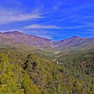
There’s a great overlook view about 5 miles up Lovell Canyon Road before that road takes a big downhill descent. You can see upper Lovell Canyon from that vantage point including the Wilson Ridgeline leading to Harris Mountain, the Harris/Griffith saddle and Sexton Ridgeline descending from Griffith Peak. That’s pretty much your entire wilderness route! I stopped there and recorded that view at the beginning of the video.
It’s been said that if you’re going to eat an elephant, take it one bite at a time! This adventure will be about 30 miles in length with an ascent of 7,000ft. Most of the terrain is pathless. It’s and elephant of an adventure that dwarfs the Charleston Loop, so take it one bite at a time. I identified seven bites:
- Lovell Canyon Trailhead to the opposite side of Lovell Canyon
- Opposite side of Lovell Canyon to the Wilson Ridgeline
- Wilson Ridgeline to its connection with Harris Mountain Road
- Wilson Ridgeline from Harris Mountain Road to Harris Mountain Summit (spent the night there).
- Harris Mountain Summit to Griffith Peak Summit
- Griffith Peak Summit Descent on Sexton Ridge to Griffith Shadow Loop Trail
- Griffith Shadow Loop Trail to Lovell Canyon Trailhead and Parking Area
I started with a 50-pound backpack weighted down with about 10 liters of electrolyte infused water. I nick-named the backpack “Godzilla”. At the end of the adventure I had 2 cups of water remaining, but had placed an extra gallon in my car. Alternately you could stash a gallon somewhere on Griffith Peak the week before in order to lighten your load. However, I believe my load lightened by about 5 pounds during each of the above “Seven Bites of the Elephant Adventure”.
Note: I had previously traversed all but a couple 1,000ft stretches of this entire 30-mile route in separate earlier adventures. This gave me a basic familiarity with the route, without which things would have been far more complicated along with danger of going off-course or getting bogged down, running out of water! I suggest you do the Harris/Griffith crossing and at least the lower Wilson and Sexton ridgelines from the Lovell Canyon trails so you can see how things connect before tackling this complete course. That’s what I did. In addition to a few trips from Harris Mountain to Griffith Peak, I’d previously gone all the way up the Wilson Ridge to Harris Mountain Summit and up and down the Sexton Ridgeline except for about a 1,000ft mid-ridgeline stretch.
Lovell Canyon Trailhead to the Opposite Side (East side) of Lovell Canyon
The initial trails are pretty straightforward. Begin on the Lovell Canyon Trail. About 1.6miles in there’s an intersection with the Lovell Canyon Loop. Take a right here, but note that at the end of the adventure you’ll be returning by the path to the left. The right turn takes you down to the Lovell Canyon main wash. There’s a well-signed canyon crossing there. It’s actually the beginning of the Griffith Shadow Loop taken in the counterclockwise direction. At times the brush in the canyon is so thick you can’t see where you’re stepping. Today there was a clear path.
Opposite Side (East side) of Lovell Canyon to the Wilson Ridgeline
Once you cross the Lovell Canyon Wash, the trail takes a left heading along the base of the ridgeline on the East side of the canyon. That’s the Wilson Ridgeline. Notice a low vertical rocky hill. Continue along the trail until you pass that hill, then a little further on to the point where the trail takes a sharp U-turn at a gully just beyond the hill. Here’s the point where you leave the trail and begin to ascend the approach ridge to toward the Wilson Ridgeline. That approach ridge ascends along the far side of the gully. There’s a lot of brush – Pointed Leaf Manzanita and Ashy Silk Tassel. These form barriers in places, but I always found pathways weaving through the brush.
Views quickly become more expansive as you’re ascending the approach ridgeline. You can see all the way up Lovell Canyon to Harris Mountain and Griffith Peak at the upper end. You can see Sexton Ridgeline descending from Griffith Peak all the way back down to where you’ll reconnect with the Griffith Shadow Loop Trail. You can also see what looks like an impossibly daunting saddle between Harris Mountain and Griffith Peak. Just know a trail will easily take you up and through the cliffs on the Griffith Peak side.
About half-way up the approach ridge there’s a rocky high point. Make the steep descent from that high point in order to continue up the approach ridge beyond. Now you’re in a pine forest. I found the forest easier to navigate than the brush below, and kept to the left edge of the forest all the way to the Wilson Ridgeline above.
Wilson Ridgeline to Harris Mountain Road Crossing
Take a left at the Wilson Ridgeline and begin ascending the main ridgeline toward Harris Mountain at the ridgeline summit. At the ridgeline summit views become immediately more expansive revealing the La Madre Mountains and Harris Springs Canyon. You can also see Angel Peak. The Sheep Range, Gass Peak and parts of the Las Vegas Valley are metro area are coming into view. Look back to see Bridge Mountain, Rainbow Mountain and Mt. Wilson emerging in the Rainbow Mountains Wilderness. Potosi Mountain stands just beyond the lower opening of Lovell Canyon.
Begin by weaving in and through a juniper and pine forest that escaped the 2013 Carpenter Fire burn. The upper Wilson Ridgeline and all of the Sexton Ridgeline are burned out. However, life is returning. The upper ridgelines are carpeted with wildflowers and the views are non-stop, like being on an mountaintop the entire way! Both ridgelines are a class 2 walk, though steady uphill…steep in a few places…just a few low rocky areas to scramble over.
Eventually, Harris Mountain Road will come into view ahead. At this point watch for a faint pathway that will take you to the Harris Mountain Road crossing and trailhead.
Harris Mountain Road Crossing to Harris Mountain Summit
There’s a trailhead with interpretive displays at the Harris Mountain Road crossing. It’s the trailhead for the Griffith Peak back wilderness trail. You have two choices here:
- Take the Griffith Peak back wilderness trail along the base of Harris Mountain to the Harris/Griffith Saddle, then on up to Griffith Peak.
- Continue up the Wilson Ridgeline to Harris Mountain Summit.
I went with the second choice in order to take in the complete Wilson Ridgeline all the way to its summit on Harris Mountain. The Griffith Peak back wilderness trail bypasses Harris Mountain summit.
There are about 4 high points to ascend along the upper Wilson Ridgeline before you reach Harris Mountain summit, and there are no paths or trails. The biggest is a tall cone-shaped high point. You’ll know it when you see it…pretty obvious. As you ascend the initial high points you’re weaving through skeleton forests of burned Mountain Mahogany. The branches are wiry and snap back if you try to move them out of the way!
Once you achieve the cone-shaped high point you’ll find that the opposite side is a beautiful pine forest, and the ridgeline has become an alpine flower-carpeted meadow. This is where the route becomes more and more incredible with every step. From the upper side of the cone-shaped high point you can now see Harris Mountain summit, the next high point not far ahead. That final ascent is more gradual, and now you’re in a magical Bristlecone Pine forest!
Harris Mountain Summit to the Harris/Griffith Saddle
Harris Mountain Summit itself is my favorite summit in the Mt. Charleston Wilderness. Almost nobody visits that summit. It’s carpeted with wildflowers, surrounded by Bristlecone Pines and there are now expansive views of upper Kyle Canyon with all the familiar peaks: Griffith, Charleston, Lee, Mummy and Fletcher! You can look down upon the upper Las Vegas Valley and watch the sunset and emerging night lights of the metro area. The next morning you can see the sun rising to the East and painting the high peaks of the Mt. Charleston Wilderness crimson.
Now it’s time to descend to the Harris/Griffith saddle. There’s no trail, but you might find a pathway to help guide your descent. Just weave your way down the steep slope and through lots of brush, sometimes quite thick. There’s always an open route. There are a few plateaus before you finally see the saddle immediately below. You’ll find the Griffith Peak back wilderness trail on the saddle. That trail will take you all the way to Griffith Peak summit.
Harris/Griffith Saddle to Griffith Peak Summit
That back wilderness trail is well constructed, easily guiding you up through the imposing looking cliffs on the opposite side of the saddle. Once you’re above the cliffs, you’ll find yourself on grassy hills. The path becomes faint and difficult to follow in places. If you lose it, just know that its route is up the grassy ridgeline, crossing over to the right side of the next rocky high points above. It rounds those next rocky points, then crosses over to the left side of the rocky points to continue upward to the base of Griffith Peak.
Once you clear the rocky high points, there are two huge slopes before Griffith Peak summit. The Griffith Peak back wilderness trail circles around the left (South) side of Griffith Peak, then ascends to the summit. I took a more direct ascent up the two huge slopes, switchbacking my way up to the summit. Most of the Harris/Griffith saddle is burned, but as you near Griffith Peak majestic bristlecones that escaped the fire begin to emerge. And there are spectacular views of the high Mt. Charleston Wilderness peaks along with upper Kyle Canyon and Mt. Charleston Village below.
Sexton Ridgeline Descent from Griffith Peak Summit
Descending the Sexton Ridgeline from Griffith Peak is through terrain similar to the Wilson Ridgeline. It’s open, with spectacular mountaintop views all the way down. The upper ridgeline is carpeted with wildflowers. You pass through the hulks of burned Bristlecone Pines. Lovell Canyon stretches out below to the East and Trout Canyon below to the West. There are a few rocky points to lightly scramble, but for the most part an easy walking route always opens before you. It’s a long ridgeline, but you’re going downhill all the way with only a very few brief rises.
Lower Sexton Ridgeline to Griffith Shadow Loop Trail
As you near the base of the Sexton Ridgeline, like the Wilson Ridgeline, a pine forest begins to emerge. You’ll find yourself moving through a beautiful pine forest on the lower ridgeline. Just before the ridgeline takes a sharp descent, angle to the left down an approach ridgeline leading toward Lovell Canyon and the Griffith Shadow Loop Trail.
Near the base of the approach ridge, the ridge angles to the right. Descend into the gully to the right and continue down that gully until you reach a pathway branching up and out of the gully to your left. That pathway will take you, in about 1,000ft, to connect with the Griffith Shadow Loop Trail where you will take a right. I realize this is not very clear when you need good directions. See the videos on this page to view this important connection.
On this day, with two broken phone charger cords, my phone battery finally gave out, preventing further videos. In addition, it was now dark. Fortunately, the trails were easy to follow with the aid of a headlamp, and keeping to the right at the few intersections brought me back to the Lovell Canyon Trailhead. You descend the Griffith Shadow Loop to the Lovell Canyon Loop and finally the Lovell Canyon Trail. Note that the upper Griffith Shadow Loop is overgrown in places. Fortunately, there was still daylight at that point. You could easily go off-trail and lose you way in the dark along that stretch!
Summary
Congratulations! This high ridgeline adventure has given you the most spectacular, complete review of Lovell Canyon and its surrounding wilderness. The canyon and the Southern Nevada greater wilderness will never look the same after this. You’ll have viewed how the vast wilderness is all interconnected, and this adventure will become a cherished life memory!