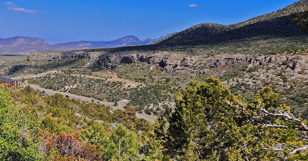
Fletcher View Ridge | Mt Charleston Wilderness, Nevada

Fletcher View Ridge ascends between The Fletcher View Campground and the final summit approach to Harris Mountain. The ridge originates in The Fletcher Canyon area on Kyle Canyon Road in The Mt. Charleston Wilderness, Nevada. Expect non-stop spectacular views of the highest peaks on The Mt. Charleston Loop along with a good aerial view of Fletcher Canyon and potential route to Fletcher Peak summit. Elevation: 7,000-9,000ft. wilderness route, no trails or trail signs. Best time of year for this adventure: July through September. Click the image or title above for details.
Fletcher Canyon Trailhead / Harris Mt Griffith Peak Circuit | Mt Charleston Wilderness, Nevada

Make a circuit from The Fletcher Canyon Trailhead to Harris Mountain and Griffith Peak, then return to your start point. After accomplishing the most direct approach to Harris Mountain summit, cross the saddle to Griffith Peak, descend to The South Loop Trailhead and finally return on Kyle Canyon Road to Fletcher Canyon Trailhead. This route is half wilderness and half trails. Elevation gain is from 7,000-11,060ft plus additional ascent and descent along the way. Best time of year for this adventure: Summer through mid-Fall. Click the title or image above for details.
Fletcher Canyon Trailhead to Harris Mountain Summit | Mt Charleston Wilderness, Nevada

Summit Harris Mountain from Fletcher Canyon Trailhead in The Mt. Charleston Wilderness of Nevada. The approach ridge is just Southwest of the trailhead. Of all the approaches to Harris Mountain summit, this approach ridge and a similar approach ridge to the West are the most direct routes to Harris Mountain summit, especially taking into account the routes begin right off Kyle Canyon Road. The traditional Harris Mountain Trailhead requires miles of approach on unpaved 4WD roads. Because of the remoteness of the traditional trailhead, Harris Mountain is seldom summited and therefore an experience of beautiful, pristine, relatively untouched nature.
Escarpment Trail | Mt Charleston Wilderness | Spring Mountains, Nevada
The Escarpment Trail in The Mt. Charleston Wilderness, Spring Mountains, Nevada is a moderate 3.6 mile loop trail around an escarpment with spectacular views of Kyle Canyon and surroundings. The trail is accessed from the Fletcher Canyon Trailhead or The Spring Mountains Visitor Gateway.
Acastus Trail | Mt Charleston Wilderness | Spring Mountains, Nevada

The Acastus Trail in The Mt Charleston Wilderness, Spring Mountains, Nevada features the nature, history and geology of the area. Many attractive interpretive signs along the way, each with a bench for rest and reflection, invite hikers to slow down, pause, take in the environment and in so doing deepen consciousness and awareness of The Spring Mountains and one’s place within that setting. Walking The Acastus Trail can be somewhat like making a spiritual pilgrimage.
Eagles Nest Loop | Mt Charleston Wilderness | Spring Mountains, Nevada

The Eagles Nest Loop in Nevada’s Mt Charleston Wilderness runs along the South base of Fletcher Peak offering spectacular views of Kyle Canyon! Click the image or title above for details.
Fletcher Canyon Trail | Mt Charleston Wilderness, Nevada
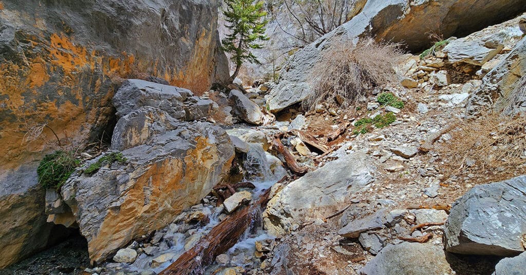
Fletcher Canyon Trail in The Mt. Charleston Wilderness, Spring Mountains, Nevada is an easy 4.2-mile round trip hike along a creek in a beautiful forested area with spectacular mountain views. It’s a great trail for altitude conditioning. Beyond the trail’s end may be a possible extreme adventure to Fletcher Peak summit.
Spring Mountains Visitor Gateway | Mt Charleston Wilderness, Nevada

The Spring Mountains Visitor Gateway in Nevada’s Mt. Charleston Wilderness offers exhibits, programs, books, souvenirs and interpretive trails. It’s a great first stop before engaging in your first adventure in The Spring Mountains.
Fletcher Canyon Trails Overview | Mt Charleston Wilderness, Nevada

Trails Accessed from The Fletcher Canyon Trailhead in The Mt. Charleston Wilderness, Nevada include Fletcher Canyon Trail; Eagle’s Nest Loop; Acastus Trail and Escarpment Trail. These are great introductory trails to the Mt. Charleston Wilderness and excellent initial altitude conditioning trails.
Mary Jane Falls | Mt Charleston Wilderness, Nevada

Mary Jane Falls is a moderate 3.2-mile round trip hike in Nevada’s Mt. Charleston Wilderness from a convenient trailhead just beyond Charleston Village. To see the falls at their best, visit them in mid-to-late Spring. Experience spectacular views of Kyle Canyon along the way, and don’t miss visiting the secret cave just beyond the falls.