Overview | La Madre Ridgeline East Saddle | La Madre Mountains Wilderness, Nevada
Where is the La Madre Ridgeline East Saddle?
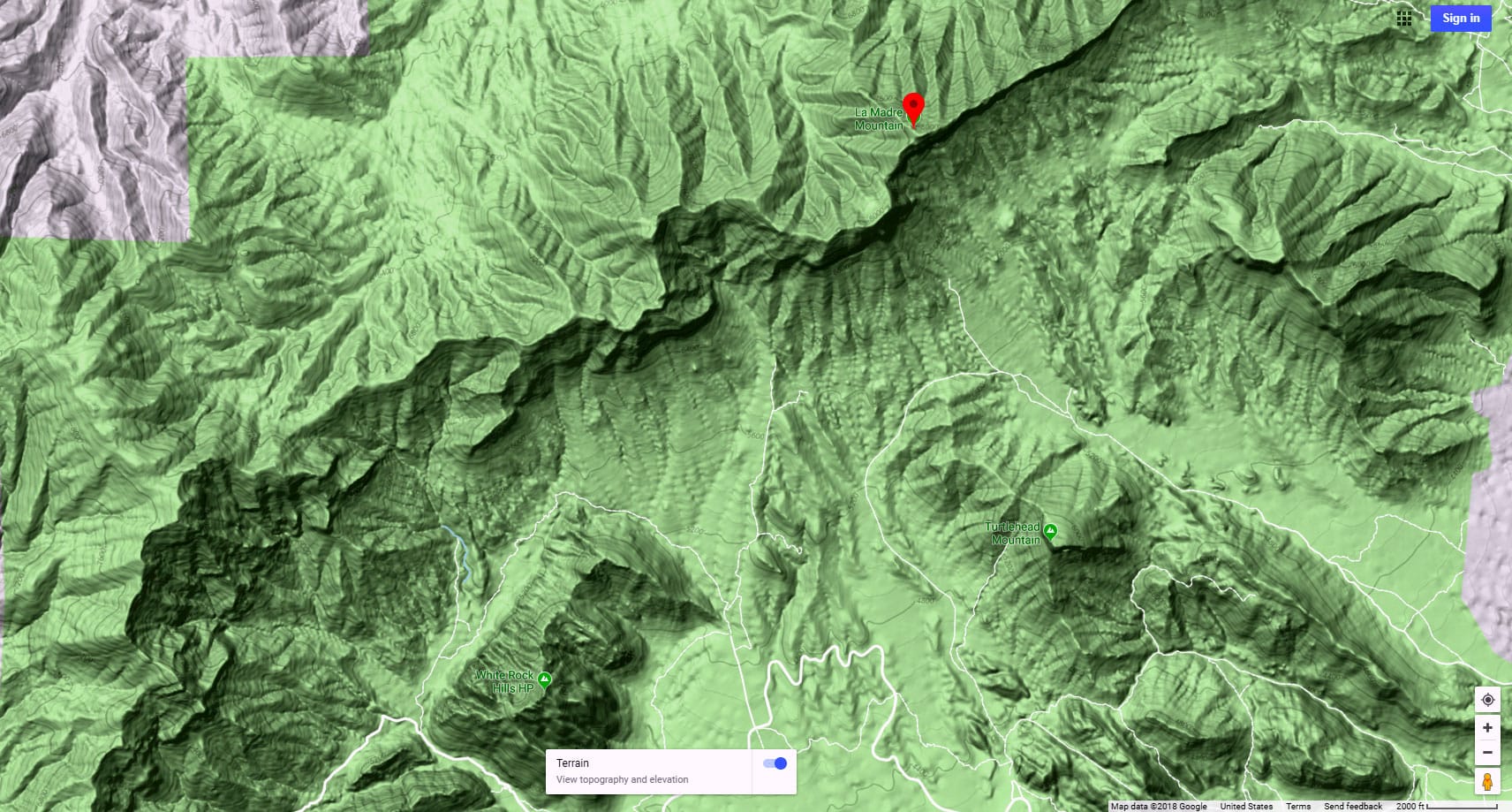
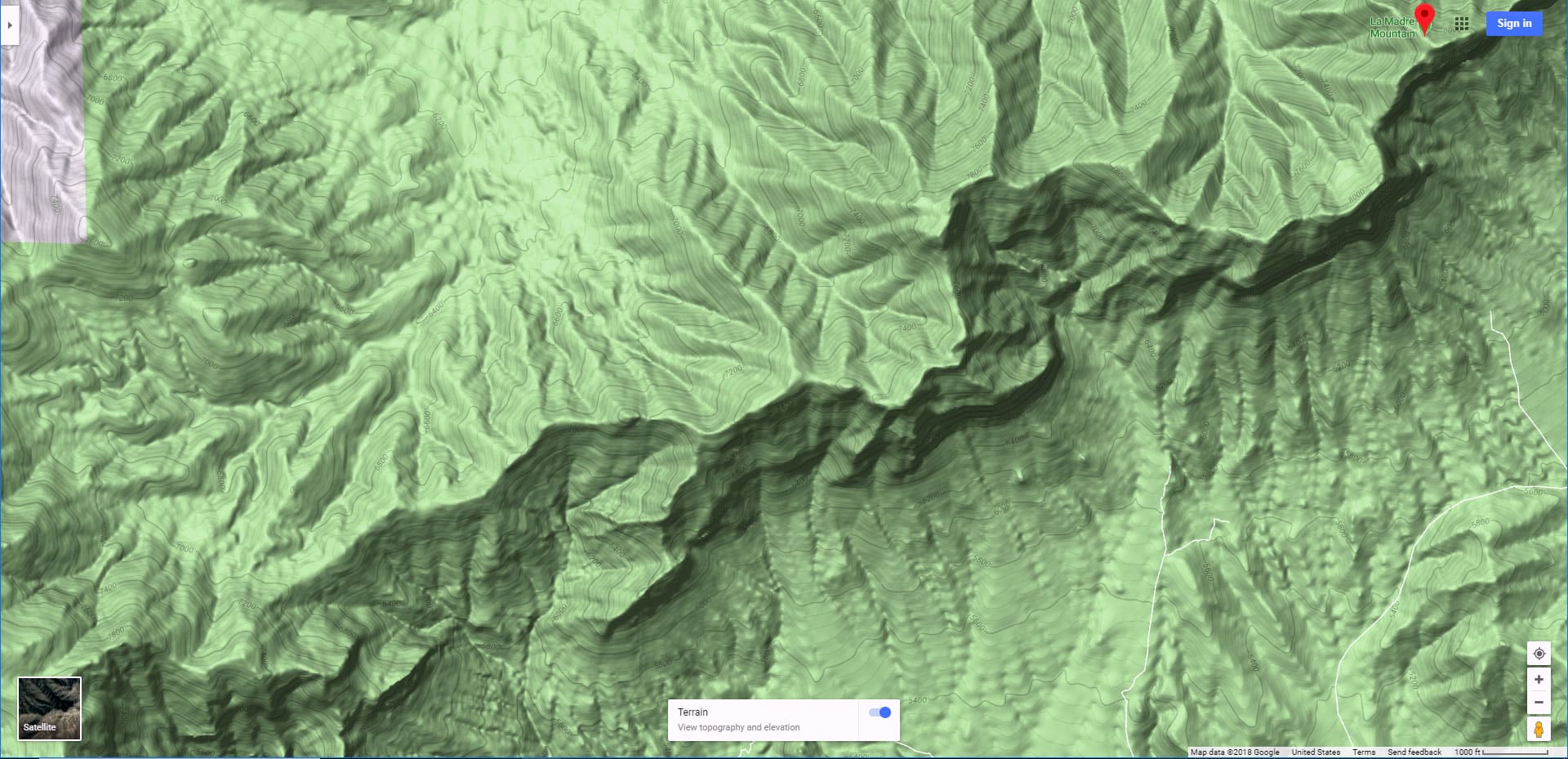
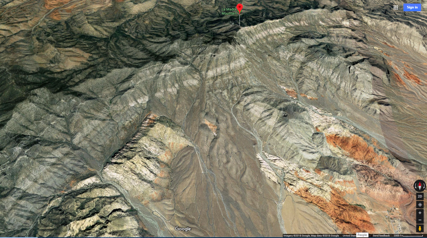
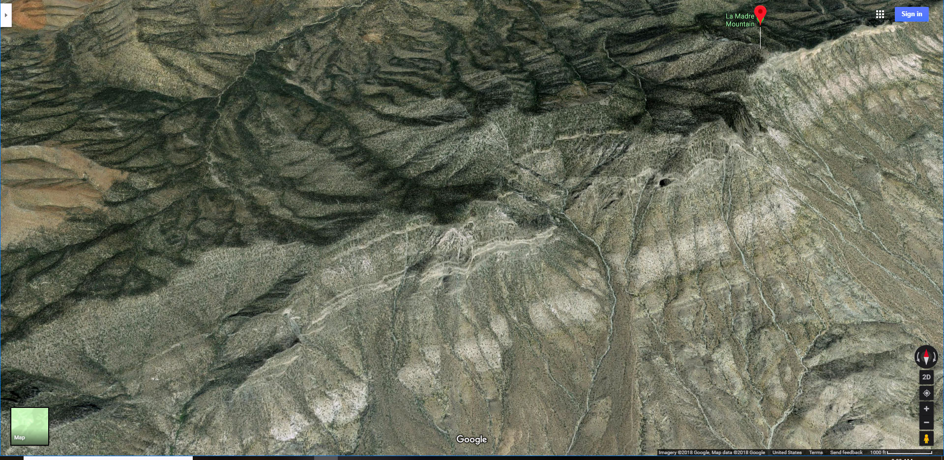
The La Madre Ridgeline East Saddle is located near the East end of the spectacular La Madre Mountains upper ridgeline between East La Madre Peak to the East and Peak 6826 and Fernande Peak to the West. While there are some good approach roads and then faint approach trails, be prepared to navigate pathless wilderness as you make your final approach to the saddle.
What Can You See from the La Madre Ridgeline East Saddle?
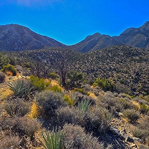
From the La Madre Ridgeline East Saddle, or along the final approach, to the North you can see Harris Springs Canyon and Kyle Canyon below. The Mt. Charleston Wilderness is visible to the Northwest. The Sheep Range and Gass Peak are visible to the Northeast.
Metro Las Vegas, the Strip, Frenchman Mountain and Little Red Rock are visible to the Southeast. Damsel Peak and Gateway Peak are across to the South. Turtlehead Peak, the Rainbow Mountains and Potosi Mountain are visible to the Southwest.
Many additional points in all directions beyond are visible.
Where Can You Go from the La Madre Ridgeline East Saddle?
There are some exciting adventure route possibilities from the La Madre Ridgeline East Saddle:
- Ascend to the East on the La Madre Mountains Eastern Ridgeline to East La Madre Peak. Create an adventure loop by descending the Eastern side of the peak to return to your starting point.
- Ascend to the West on the La Madre Ridgeline all the way to the summit of La Madre Mountain. Create a huge adventure loop by descending the La Madre Mountain North Ridge to return to your starting point. Alternately, shorten the loop by descending at Peak 6826, Fernande Peak or Peak 7080.
- Create an Eastern La Madre Ridgeline Grand Crossing Loop by circling around the lower East end of the La Madre Ridgeline, then ascending through the Saddle back to your starting point.
All these adventures offer spectacular mountaintop views most of the way along with the experience of the La Madre Mountains upper ridgeline and the wilderness areas to the North and South. I strongly recommend you test these adventures in small parts before taking on more extensive routes and loops. This is what I did. Test out the parts, become familiar and comfortable, then begin to string them together.
What is the Best Time of Year to Visit the La Madre Ridgeline East Saddle?
Here’s the challenge: You need lots of daylight for the more extended Saddle adventures, but the longest days (Summer) can also bring dangerously high (100+ degree) temperatures. The coolest Winter days are short and can bring snow and ice on the upper ridgeline. This leaves the longest Spring or Fall days you can manage. Mid-day Vegas Metro Area temperatures around 80 degrees create the best conditions to visit the Saddle. An out-and-back adventure just to the saddle is possible into early Winter before the snows and into late Spring as long as temperatures before temperatures rise to uncomfortable or dangerous levels.
Directions to Route Starting Point | La Madre Ridgeline East Saddle | La Madre Mountains Wilderness, Nevada
This adventure reaches the La Madre Ridgeline East Saddle from a parking area on Kyle Canyon Road to the North. Take Hwy 95 North from Las Vegas. Exit left onto Kyle Canyon Road toward Mt. Charleston (around the end of the Northern metro area). In about 3 miles, shortly beyond the edge of the housing and horse ranch area, watch for a small trailhead parking area on the left (South) side of Kyle Canyon Road.
Narrative Guide | La Madre Ridgeline East Saddle | La Madre Mountains Wilderness, Nevada
Getting Your Initial Bearings
From the trailhead parking area look South to see the Harris Springs Canyon area, a huge opposite ridgeline and parts of the La Madre Mountains Upper Ridgeline peaking above on the horizon. Toward the East (Las Vegas) is another huge ridgeline I call the Harris Springs Canyon Ridgeline with Peak 6080 as its high point.
Adventure Route Summary
Begin by heading South about a thousand feet, then descending into the massive Harris Springs Canyon Wash. Turn left in the wash and circle around the lower left end of its opposite ridgeline. Then head South up the valley along the base of Harris Springs Canyon Ridgeline toward the now visible La Madre Mountains Ridgeline. An unpaved road will guide your way. Where the road “Ts” off near the base of the La Madre Mountains Upper Ridgeline, turn right (West) to reach the Saddle approach ridgeline. Take that nice gradual ridgeline up to the Saddle final approach, then continue on the rocky final approach another half-mile to the Saddle.
Trailhead Parking to the Approach Valley Along the Base of Harris Springs Canyon Ridgeline
An old unpaved road will take you from the trailhead parking area 1000ft South and then down into Harris Springs Canyon. Note that no motorized vehicles are allowed on this road, so you’ll need to travel on foot. Once you descend into the base of Harris Springs Canyon, head left (East), watching for a way to cross the steep walls at the opposite side of the canyon wash (an opening will occur within 500-1000ft). This is, in my thinking, the most complicated part of the entire adventure! After ascending the opposite side of the wash, find a trail leading down into the approach valley and road along the base of Harris Springs Canyon Ridgeline. The road heads South toward the now visible La Madre Mountains Ridgeline.
Base of the La Madre Mountains Ridgeline to the Saddle Approach Ridge
Where the road “Ts” at the base of the La Madre Mountains Ridgeline, turn right, continuing for a half-mile or so until the road makes a significant dip to cross the large canyon wash that empties from the Saddle on the ridgeline above. At the point where the road begins to descend, leave the road and cross the wash to the opposite ridgeline. This is the Saddle approach ridgeline. Notice how the Saddle wash is narrow and deep with rocky walls on either side. You want to ascend the ridgeline above the West side of that deep canyon wash. See the video and slide guides on this page to identify the Saddle approach ridgeline.
Saddle Approach Ridgeline to the Final Saddle Approach
The Saddle approach ridgeline is long and gradual, basically a class 2 walk. There’s actually a faint cairned trail on the ridgeline that will take you all the way to the final Saddle approach. However, that trail will at times disappear. Just navigate along the center of the approach ridgeline, and you’ll come across the trail again. The trail does at times help streamline your ascent as it weaves around brush and rocky areas, but don’t waste time trying to find and stay on the trail.
The approach ridgeline will reach the upper La Madre Ridgeline at the base of East La Madre Peak. Here is where the approach ridgeline ends, its faint trail ends and you begin navigating pathless wilderness.
Final Saddle Approach
You want to traverse East La Madre Peaks slope toward the saddle, only about a half-mile away. The traverse is pathless, though with careful study you can discover a route along the slope all the way to the Saddle. For the approach I took a fairly direct route to the Saddle, weaving around the base of some intervening rocky areas. I took a higher route on the return, avoiding some of those rocky areas, but in the end not significantly better or faster. You just need to navigate this rocky, steep pathless stretch on the final Saddle approach. There’s no need for any technical climbing beyond a light class 3 rock scramble in a few places. The final approach can be a fairly easy walk, with an emphasis on the words fairly easy. The terrain levels off as you near the Saddle, and the views and route possibilities from the Saddle make all the effort worthwhile! See the descriptions above.


