Overview | La Madre East Ridge Approaches | La Madre Mountains Wilderness, Nevada
Adventure Slide Guide to appear week of 11/2/2025!
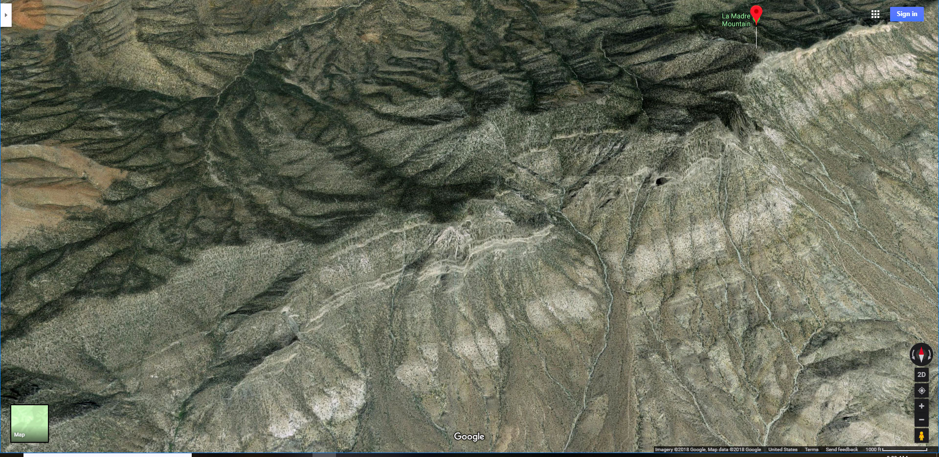
Close to Civilization, Yet So Remote!
The largely unknown, untouched and therefore pristine wilderness at the Northern base of the Eastern La Madre Ridgeline is only about 10 miles from Metro Las Vegas. Its isolation is due to the fact that there are no asphalt access roads and entrance points to the few unpaved roads is obscure. Beyond the few dirt roads it’s all pathless wilderness. As you move through this wilderness you may feel as if you’re hundreds of miles from civilization!
Beautiful, Rugged Terrain Full of Surprises
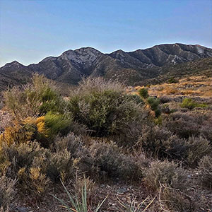
The lower terrain is stark desert sage and cacti. But as you ascend the base of the La Madre Ridgeline you soon find yourself in a beautiful Juniper and Pine forest. And the surrounding views continually expand to include Gass Peak, the Sheep Range and the Mt. Charleston Wilderness. Soon you’re weaving around and up through limestone formations, once an ancient sea bed (450 million years ago), now solidified into limestone encrusted with ocean fossils.
Peaks Along the Eastern La Madre Ridgeline
Each of the peaks along the upper La Madre Ridgeline has its own approach spur (ridgeline) and gully. The upper peaks from West to East (moving toward Metro Las Vegas) are:
The peaks I have video documented are linked. I hope to visit and video document the others soon. Additional remarkable features on the La Madre Ridgeline include:
- Devil’s Slide – A massive 1000ft high near vertical ancient limestone slab.
- The Eastern La Madre Ridgeline Saddle Crossing – A passage down to Little Red Rock on the South side of the ridgeline.
Adventure Route Summary
This adventure begins at a trailhead parking area on Kyle Canyon Road just beyond the horse ranches. Then it takes a combination or unpaved roads and pathways along the base of the La Madre Ridgeline. As the roads end, continue through pathless wilderness to the base of Devil’s Slide on the North side of La Madre Mountain. Finally, return by a route higher along the pathless base of the La Madre Ridgeline, crossing the lower end of the ridgelines and gullies that lead up to the peaks on the La Madre Ridgeline.
Best Time of Year to Visit the Eastern La Madre Ridgeline
This is an adventure for Spring and Fall. Winter can bring snow and ice; Summer can bring dangerously high temperatures. Ideal conditions exist when mid-day temperatures in the Las Vegas Valley are predicted to reach a high around 80 degrees.
Route starting Point Directions | La Madre East Ridge Approaches | La Madre Mountains Wilderness, Nevada
This adventure reaches Devil’s Slide on La Madre Mt. from a parking area on Kyle Canyon Road to the North. Take Hwy 95 North from Las Vegas. Exit left onto Kyle Canyon Road toward Mt. Charleston (around the end of the Northern metro area). In about 3 miles, shortly beyond the edge of the housing and horse ranch area, watch for a small trailhead parking area on the left (South) side of Kyle Canyon Road.
Narrative Guide | La Madre East Ridge Approaches | La Madre Mountains Wilderness, Nevada
Getting Your Initial Bearings
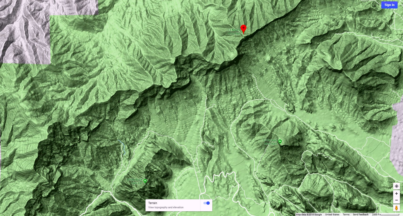
From the parking area on Kyle Canyon Road look South to see the tip of the Eastern La Madre Ridgeline on the horizon above the intervening high ridgeline. Harris Springs Canyon Wash runs along the base of that intervening ridgeline. Looking East toward Metro Las Vegas, the metro area is hidden behind another high ridgeline I call Harris Springs Canyon Ridgeline with its high point Peak 6080.
Kyle Canyon Road to the La Madre Wilderness Entrance Sign
Your adventure route will be to head South for about 1000ft, descend into Harris Springs Canyon Wash, circle the opposite ridgeline around it’s East (left) base to connect with the unpaved road network. Take the unpaved road up a beautiful valley toward the now visible La Madre Ridgeline. Turn right when the road reaches the base of the La Madre Ridgeline and continue West up the road as it parallels the base of the La Madre Ridgeline. There is a parking area and a vehicle barrier a couple miles up the road, marked by a beautiful La Madre Wilderness sign.
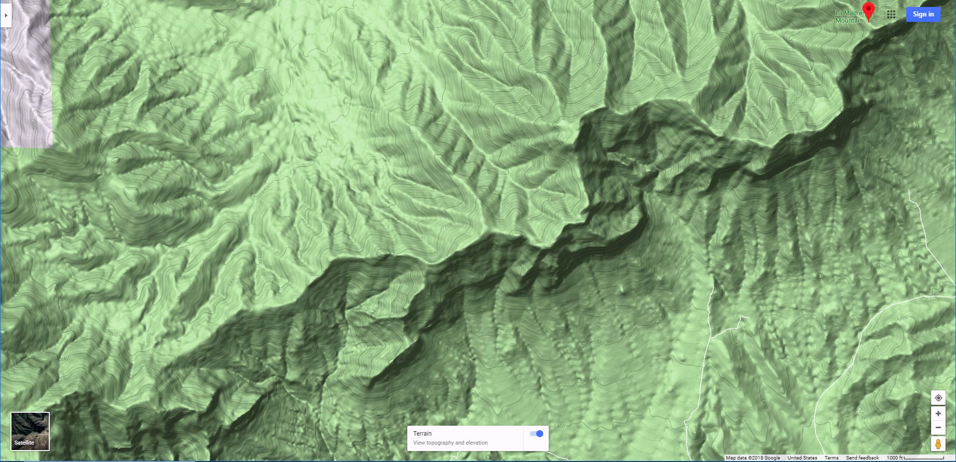
La Madre Wilderness Entrance Sign to the Network of Washes and Ridges
Continue on foot past the vehicle barrier along the old, unused continuation of the unpaved road. Below to your right is a baseline wash with a huge, beautiful limestone slab packed with ancient fossils! Ahead, to the West is the gradual North La Madre Ridgeline that eventually leads to the summit of La Madre Mountain. Below to your left is a network of baseline washes leading upward and East to the base of Devil’s Slide and Devil’s Ladder.
Washes and Ridges to the Base of Devil’s Slide
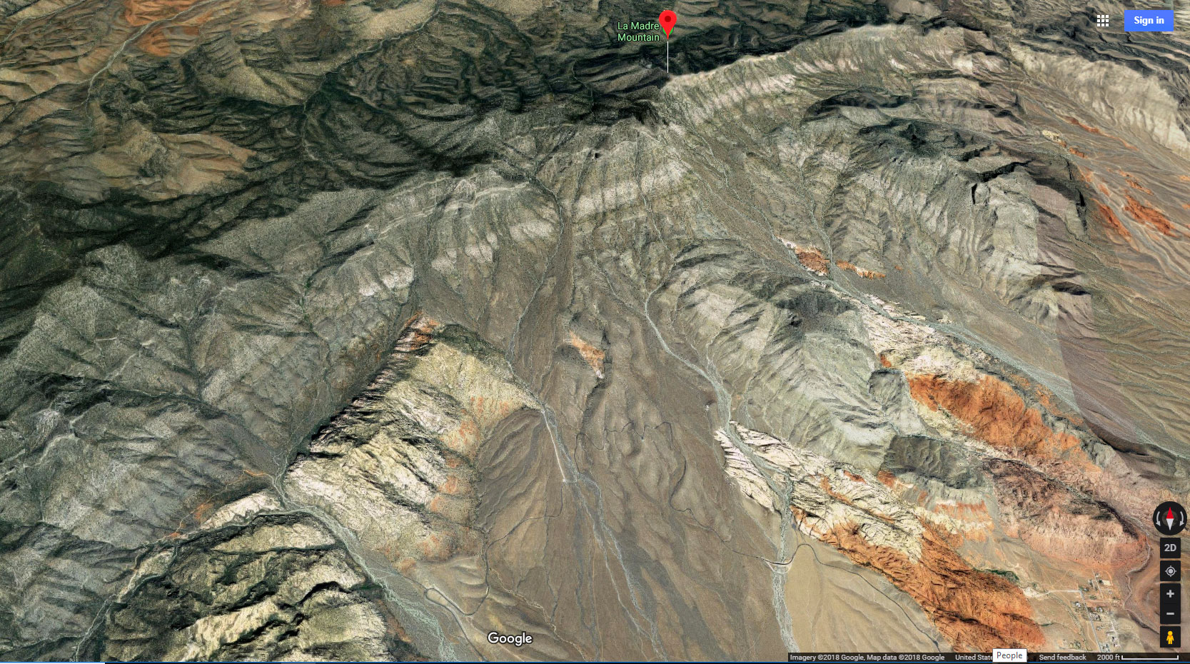
For this adventure, I continued along the old road until it ended, then descended into the network of lower washes in hope of reaching the base of Devil’s Slide at the base of La Madre Mountain at the far end of the Eastern La Madre Ridgeline. The network of intervening ridges and washes slowed me down enough that I reached my turn-around point about 300 feet below the base of Devil’s Slide. There I had begun ascending Devil’s Ladder, a ridgeline just East of Devil’s Slide leading up to La Madre Mountain’s Summit. The intervening terrain to the base of Devil’s Slide looked too complicated and time-consuming for this day–lots of class 3 limestone rock scrambling. Devil’s Ladder deserves that name. The rocky incline dramatically increases ahead. I’m saving that for a future adventure on a longer day.
Return Along the Base of the Eastern La Madre Ridgeline
The return, skirting the base of the Eastern La Madre Ridgeline is through a beautiful, fairly open Juniper and Pinyon Pine forest. Look up to your right often to see the peaks on the upper La Madre Ridgeline. Notice how each peak has its own ascent ridgeline and gully. I’ve marked each of these ascent routes on the map on this page. Each of these routes would make a grand future adventure involving a very steep ascent with some intervening class 3, and maybe class 4 limestone rock scrambles, but possibly nothing beyond class 3. I eventually reach the lower Peak 6826 ridgeline and descended that back toward the old road. One lower gully crossing brought me back to the old road, then to the La Madre Wilderness entrance sign and ultimately back to my starting point on Kyle Canyon Road.
Streamlining This Adventure
To streamline time and distance, I recommend driving the unpaved road (you’ll need to find the vehicle access point) to the La Madre Wilderness entrance sign and hiking from there. Alternately, you could take an ATV or mountain bike. This would save you enough energy and time to reach Devil’s Slide and La Madre Mountain on the upper La Madre Ridgeline. You might even camp at the La Madre Wilderness entrance sign area to begin your adventure early the next morning. Note that there’s a good chance all of the destinations I’ve pointed out may possibly be achieved mainly at a class 2 walk with a bit of occasional class 3 rock scrambling–no need to reach the more technical class 4 level of ascent. However, I can only fully vouch for the route I took on this adventure.


