Overview | Leaning Arch Loop | River Mountains | Lake Mead NRA, Nevada
Description of the Leaning Arch
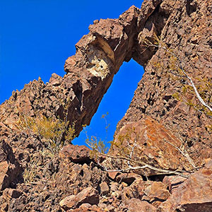
The Leaning Arch is a magnificent 30ft tall by 6ft wide formation in the River Mountains less than 3 miles from the Railroad Pass Casino on the South end of Las Vegas. You can easily stand in the arch and view Metro Las Vegas to the North and the Black Canyon and Eldorado Wilderness areas to the South. Many other points are visible from this spectacular vantage point.
Make Your Adventure Challenging, Easy or Both
The loop to and from the Leaning Arch presents a variation in difficulty levels. The more challenging North side of the loop includes some steep loose rock volcanic slopes summiting 3 high points along the way, the most significant being Easter Island Peak and Leaning Arch Peak. The South side of the loop, on the other hand is a far easier traverse covering most of the distance on a nice trail with gradual inclines before a final ascent to the arch up a fairly gradual gully and slope. You could do an easy or a challenging out-and-back to the arch by taking either the South or North side of the loop.
For this adventure we took the loop in a clockwise direction from North to South experiencing the challenging slopes at first before finishing on the easy trail.
What You’ll See Along the Leaning Arch Loop
Watch for the following points of reference in the distance (clockwise):
There’s far more visible, these are some of the most prominent reference points you will observe.
Best Time of Year to Visit the Leaning Arch
The best time of year for this adventure is late Fall through early Spring. Summer temperatures can easily reach dangerously high levels exceeding 120 degrees!
Route Starting Point Directions | Leaning Arch Loop | River Mountains | Lake Mead NRA, Nevada
Take I-11 South from Las Vegas, then take the Railroad Pass exit #15a toward the Railroad Pass Casino and travel center. Turn right just before reaching the travel center to arrive at the trailhead parking for the River Mountains Loop Trail. This adventure begins from the same parking area.
Narrative Guide | Leaning Arch Loop | River Mountains | Lake Mead NRA, Nevada
Getting Your Initial Bearings
From the trailhead parking area, look East to the hills immediately above. This is the Southwest corner of the River Mountains. Looking to the West across I-11 you can see another group of mountains. These are the Railroad Mountains. To the South you’re looking toward the Black Mountain and Eldorado Wilderness areas. To the Southeast is the Hoover Dam area, to the Southwest is Highway 93 heading toward Searchlight. Extending from the North side (Las Vegas side) of the parking area is an asphalt pathway. This is part of the River Mountains Loop, a 34-mile walking, running and bike riding trail completely circling the River Mountains.
Trailhead Parking Area to the Initial Approach Gully
We took the Leaning Arch Loop in a clockwise direction. Begin heading up the pathway on the North side of the parking area. Soon, take a right turn off the pathway, crossing the railroad tracks that skirt the base of the River Mountains. Then continue along the base of the River Mountains for about 1,500ft along a to reach a very distinctive gully descending from the mountains above.
Initial Approach Gully to Easter Island Peak
Looking up the gully you can see a ridge ascending along its upper right side arriving at your initial high point above the gully summit. The ridgeline then continues, circling above the gully summit as it heads to the left toward a second, much higher point above. That second high point is Easter Island Peak: Your second high summit.
Head up ridge along the upper right (South) side of the gully. It’s steep with a loose volcanic rock surface, but there are many solid footholds and a faint pathway will help guide your ascent. This is one of three steepest slopes you will encounter on the North side of the Leaning Arch Loop. Once you reach that initial high point above the gully, the incline becomes a bit more gradual as it continues to Easter Island Peak. Along the way, stop to notice how rapidly the surrounding views are expanding. The Railroad Pass Casino area is soon far below, there’s much better view of the Railroad Mountains across Highway 1-11, and Metro Las Vegas is beginning to emerge to the North.
Soon you’ll arrive on the summit of Easter Island Peak for a much more spectacular 360-degree surrounding view! Easter Island Peak is a long summit area topped by three large cairns evenly spaced. These cairns are likely the inspiration for the name of the peak. Looking to the East the next peak is Leaning Arch Peak. You’ll need to cross the deep saddle between the two peaks.
Easter Island Peak to Leaning Arch Peak
The most challenging slopes you will face are the Eastern slope of Easter Island Peak and the Eastern slope of Leaning Arch Peak. Begin by descending the steep slope from Easter Island Peak to the saddle below. You’ll find a winding pathway through the loose volcanic rock surface, finally arriving at the saddle below. The ascent to Leaning Arch Peak is a bit more gradual. The 360-degree view at the summit of Leaning Arch Peak is similar in scope to that of Easter Island Peak, but with some cool variations in surrounding reference points. Some include a better view of the lush green Cascata Golf Club lawn below (watch for a flock of Bighorn Sheep there) and views of the River Mountains to the North and East along with Boulder City.
There’s another deep saddle below Leaning Arch Peak. Some rocky formations ascending just above the far side of the saddle include the Leaning Arch. However, you can’t see the arch as you’re seeing a side view.
Leaning Arch Peak to Leaning Arch
Looking down the East side of Leaning Arch Peak toward the saddle below may seem like looking over the edge of a cliff! This is the steepest slope you will encounter on the Leaning Arch Loop. Any pathways you find along the way down were probably originally created by Bighorn Sheep who are far more adept at navigating this kind of terrain. At the moment, they’re likely enjoying a peaceful meal on the lawn of the Cascata Golf Course far below as they look up and laugh at you for traversing such steep, barren slopes with far lesser skills than they possess!
Still, along the way down this steep slope, there are enough firm footholds that you can be secure all the way down…just place every step carefully and take your time! Once you reach the saddle below, you’re only a few hundred feet from the Leaning Arch, up the opposite slope. That slope is far more gentle, and before you know it, the Leaning Arch will suddenly appear in all its glory! We approached the Leaning Arch from the North side. It’s an easy 30ft ascent to stand directly beneath the Leaning Arch. Enjoy the spectacular views to the North and South from the center of the Arch. Don’t miss looking straight up to see the upper center narrowing to a point with a perfect “V” formation on either side. See the slide show on this page.
Leaning Arch to the Return Trail Below
Looking below to the South, you can see a nice, distinctive trail winding around the hills back toward your starting point at the Railroad Pass Casino area (which itself is not visible). There’s somewhat of a rocky slope descending across a few intervening gullies to arrive at the return trail below. But after that steep descent from Leaning Arch Peak, the ease of the descent from Leaning Arch to the return trail will be a welcome relief! Be sure to notice that volcanic formations on this stretch. As with the entire loop, they range from something looking like the frozen excretions from a toothpaste tube to multi-colored slopes. And a closer look at the rocks will reveal many various types of rock pushed upward by volcanic activity deep below. There isn’t a lot of plant life, but the small cacti revealed with careful observation also present an unexpectedly wide variety.
Return Trail Back to the Railroad Pass Casino Trailhead Area
Once you reach the return trail it’s easy going back to the trailhead. Note that there is one trail split along the way. The left split takes you down to the River Mountains Loop Trail where you can then turn right and continue back to the trailhead. That’s the most gradual return. The right split is a quicker, more direct circuit back to the trailhead area, and not measurably more difficult. We took the right split as seen in the video and on the map. I believe this trail has a name, the Sh*t Trail. As you round the hills and begin to see the trailhead area below, angle left toward the trailhead, crossing the intervening railroad tracks. Here you will find some large interpretive displays describing the River Mountains Loop Trail and the history of the Railroad Pass Casino (see the video and slide show on this page).
Summary
Congratulations! You’ve successfully completed a short 5-mile adventure to a fabulous destination point: The Leaning Arch! Along the way you’ve navigated a wide variation of terrain from easy to challenging.