Overview | La Madre Ridgeline Eastern Grand Crossing Loop | La Madre Mountains Wilderness, Nevada
The Earlier Western Grand Crossing
This is the second grand crossing of the spectacular La Madre Mountains Ridgeline. The first Grand Crossing occurred further West, from Kyle Canyon, over the ridge just West of El Bastardo Peak and descending through La Madre Springs.
This Eastern Grand Crossing
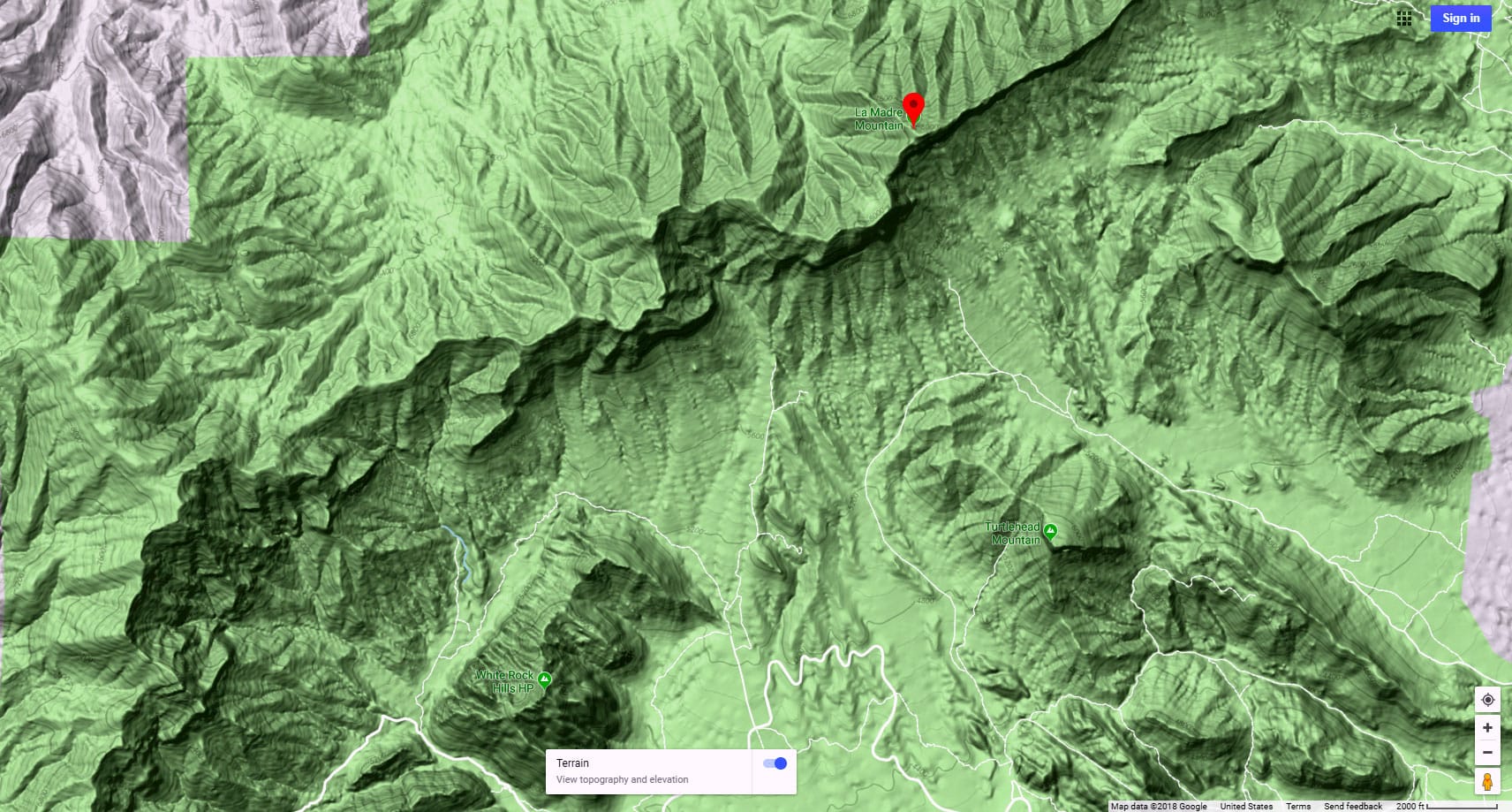
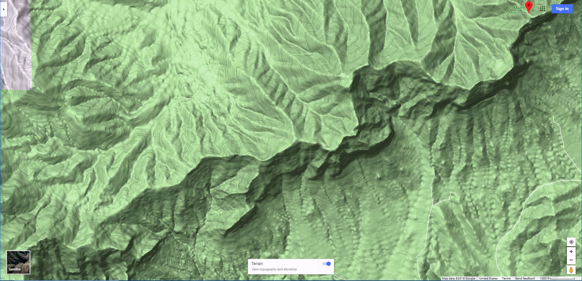
This Grand Crossing begins in Kyle Canyon, crosses the La Madre Ridgeline through a saddle just West of East La Madre Peak, then circles around the Eastern base of the La Madre Ridgeline before returning to the starting point in Kyle Canyon. I originally set out to reach Fernande Peak, but diverted to the saddle and ridgeline crossing this day due to the complicated looking vertical cliffs around Fernande Peak, which merit more exploration on a day with more daylight hours. This day was only a week from the shortest day of the year, December 21st, marking the Winter Solstice, when the Earth’s tilt gives us the least daylight (10 hours, 19 minutes).
Why a Grand Crossing of Nevada’s La Madre Ridgeline?
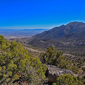
Grand crossings are amazing in that they bind together two different worlds, in this case the mountainous forested limestone world to the North and the more arid, desert-like, yucca, cacti and red rock sandstone world to the South. To make one of these grand crossings is to slowly transition through multiple altitude zones roughly between 4,400 and 6,800 feet, feeling and experiencing that transition every step of the way. When you reach the central ridgeline you can at once see the two worlds from that vantage point. It’s a life-changing experience. In the process you yourself may have made a transition in your own understanding and in your awareness of the world.
Adventure Route Summary
Beginning at a trailhead parking area just beyond the horse ranches on Kyle Canyon Road, cross the massive Harris Springs Canyon, then take a right to ascend a road through the La Madre Approach Valley along the West base of Harris Springs Canyon Ridgeline. Take the right split in the road as it reaches the base of the La Madre Ridgeline. Continue to the end of that road at the well-marked La Madre Wilderness Eastern entrance. From there, leaving your last road or trail for a long time, descend through the wilderness toward the La Madre Ridgeline, then ascend the Peak 6826 approach ridge to its summit on the La Madre Ridgeline.
Now, take a left and descend to the Eastern Saddle below that summit. Once on the Eastern Saddle, descend to the South toward the Little Red Rock area, but angling to the left (East) along the Southern base of the La Madre Ridgeline. There is a trail down there. I took this trail earlier during the La Madre Ridge East Base Circuit. This time I missed it and ended up wandering through ridgelines, low peaks and gullies along the South base of the La Madre Ridgeline.
At the East base of the La Madre Ridgeline connect with an unpaved road that will take you around the East Base of the ridgeline, through the Northeastern pass, back down through the La Madre Approach Valley you ascended earlier and finally back to your starting point on Kyle Canyon Road. The entire circuit is between 14 and 15 miles, but complicated by a lot of wilderness traverse with ascent and descent of about 2,000ft along the way!
Note that the last 15% of this adventure, less than a week from the shortest day of the year, was after sundown. That’s the part around the East base of the La Madre Ridgeline and back to the starting point. Fortunately, that stretch is fully documented in daylight on the La Madre Ridge East Base Circuit adventure.
Spectacular Reference Points You Will See Along the Way!
Much of this adventure is like being on a mountaintop the entire way! You’ve got spectacular views North, South, East and West. Here is a short list of the reference points you will see:
Click the links above to view adventure interactive map guides, video guides, slide guides and narrative guides to these destinations.
Best Time of Year for This Adventure
The main consideration is to pick a day with the most daylight but avoid Winter snow or Summer’s dangerously high heat. My best suggestion is Fall (until Winter’s deep snow reaches below 6,000ft) and Spring (until mid-day temperatures in Las Vegas exceed 90 degrees).
Route Starting Point Directions | La Madre Ridgeline Eastern Grand Crossing Loop | La Madre Mountains Wilderness, Nevada
This adventure reaches the La Madre Ridgeline East Saddle from a parking area on Kyle Canyon Road to the North. Take Hwy 95 North from Las Vegas. Exit left onto Kyle Canyon Road toward Mt. Charleston (around the end of the Northern metro area). In about 3 miles, shortly beyond the edge of the housing and horse ranch area, watch for a small trailhead parking area on the left (South) side of Kyle Canyon Road.
Narrative Guide | La Madre Ridgeline Eastern Grand Crossing Loop | La Madre Mountains Wilderness, Nevada
Getting Your Initial Bearings
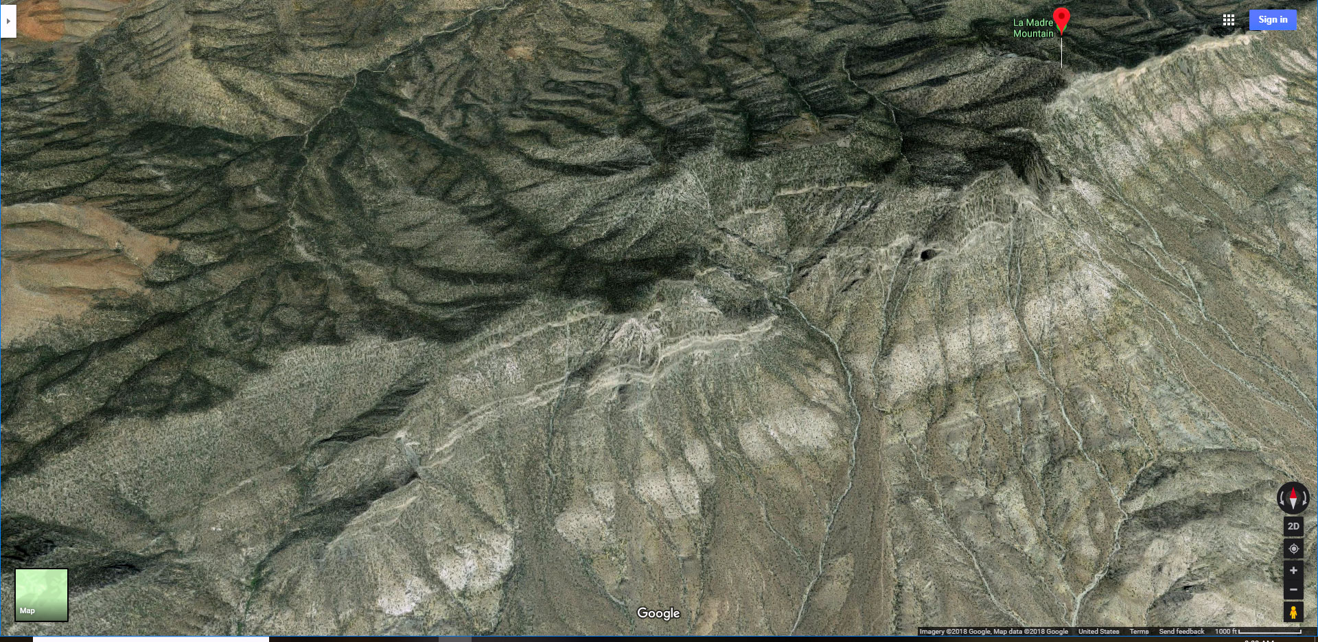
You can see important parts of the Northern half of this Grain Crossing Loop from the parking area. To the South is a long low ridge, just across the massive Harris Springs Canyon. Over that ridge you can see the tip of the La Madre Ridgeline. The highest point on the right is La Madre Mountain. To the left is Fernande Peak. Further to the left there is a dip in the ridgeline. That’s the Eastern Saddle, your half-way point. To the left of that dip is East La Madre Peak at the very East end of the La Madre Ridgeline. To the left of that is a high ridgeline separating you from the Las Vegas Metro Area. I call this Harris Springs Canyon Ridgeline. Along the base of Harris Springs Canyon Ridgeline is a valley I call the La Madre Ridgeline Approach Valley.
Starting Point Parking Area to the La Madre Approach Valley
From the parking area, head South, toward the La Madre Ridgeline, then descend into Harris Springs Canyon which is just about 1,000ft from the parking area. Once in Harris Springs Canyon you need to angle left and cross the canyon, rounding the left edge of the long ridgeline on the opposite side. This is a bit of a complicated traverse with no trails until you reach the opposite side of the canyon. There you will find a trail. Turn left on the trail and take it down, angling to the right and into the next valley I call the La Madre Approach Valley.
La Madre Approach Valley to the La Madre Wilderness East Entrance
Once you’re in the La Madre Approach Valley, you get your first good view of the La Madre Ridgeline. Turn right onto an unpaved road in that valley, heading toward the La Madre Ridgeline. Near the base of the La Madre Ridgeline the road splits. Take the right split heading West along the base of the La Madre Ridgeline. In less than 2 miles, the road will end at a parking area with a large La Madre Wilderness entrance sign.
La Madre Wilderness East Entrance to the Base of Peak 6826 Approach Ridge
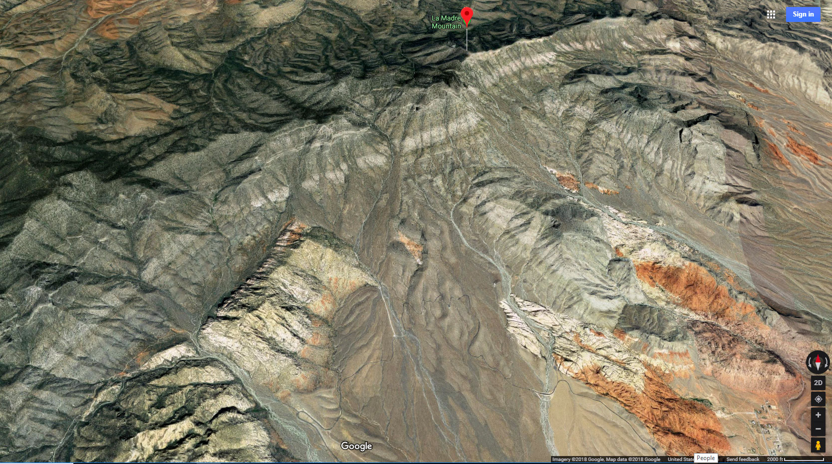
At the La Madre Wilderness East Entrance area, get your bearings again. Look up to see from right to left La Madre Mountain (the highest point on the La Madre Ridgeline). From there the ridgeline descends to the left (East) to the huge rocky, cliffy Fernande Peak. To the left beyond Fernande Peak there is a smaller peak. That’s Peak 6826. Beyond that peak, to the left is a low point in the ridgeline. That’s the Eastern Saddle. Then the ridgeline ascends to a long high point, East La Madre Peak and its summit ridgeline.
The next stretch of your adventure is to descend from the La Madre Wilderness East Entrance area, heading through pathless wilderness toward the currently hidden base of Peak 6826’s approach ridge. To get to that approach ridge you’ll need to cross a low ridge, then descend into a complicated wash heading toward the approach ridge. There’s a lot of weaving around brush and different low channels in the wash. Just keep heading toward Peak 6826 until the base of its approach ridge appears for the first time.
Base of Peak 6826 Approach Ridge to Peak 6826
Ascending the Peak 6826 approach ridge is like being on a mountaintop the entire way! What a view! Mt. Charleston Wilderness is to the West, the Sheep Range and Gass Peak are to the Northeast. As you ascend the Peak 6826 approach ridge take a good look at the limestone rocks and boulders on its surface. Limestone is frozen sea mud from an ancient sea that covered the area 500 million years ago. The sea creatures died, then dropped into the muddy sea bottom where the calcium in their bones and shells mixed with the mud turning it into limestone, a kind of cement. Many of the rocks, boulders and ledges on the approach ridge are embedded with countless 500 million year old sea fossils!
The terrain on the approach ridge all the way to the final summit area is an easy class 2 walk. You can’t actually see Peak 6826 while ascending its approach ridge. You see a high point preceding that peak. Up near that high point there is some light class 3 rock scrambling. I circled around the right side of the high point where there was one brief exposed traverse…just a few steps. Not bad. The drop below was about 20ft. Peak 6826 appears on the other side of that first high point, just a couple hundred feet along the short level ridgeline between.
As noted, the summit cliffs along the base of Peak 6826, about 100ft or so high, looked imposing enough to merit exploration on a day with more daylight hours. Fernande Peak, just to the right is lined with higher and more imposing cliffs (300ft high?). My next move on a longer Spring or Fall day might be to descend toward Fernande Peak from La Madre Mountain above.
On this day I looked down to the right to see the Eastern Saddle not far below, with a nice approach route down a gully and around to the saddle. It looked like a great opportunity to make the Eastern Grand Crossing of the La Madre Ridgeline!
As a side note, the Peak 6826 approach ridge is a much easier way to get to the Eastern Saddle than the approach ridge just to the East which I had taken on my first hike to the saddle. That other approach requires a long, complicated traverse across steep loose-rocky slopes along the Western base of East La Madre Peak.
Descending to the Eastern Saddle
This was an easy descent, at first winding down a large gully, then angling around to the right and over to the saddle. Curiously, once on the saddle I looked up toward Peak 6826 to see another gully leading up to that peak’s summit area. Save that for another adventure on that longer day!
Descending South from the Saddle Toward the East Base of the La Madre Ridgeline
There’s a huge gully to the South below the saddle. It’s steeper at first, but soon the angle of incline decreases. I headed down the center of the gully, easily weaving around the steeper loose rock areas. Then I began angling to the left (East) below the high cliffs of East La Madre Peak. I was looking to connect with a nice trail I’d taken earlier from the other direction when I’d rounded the East Base of the La Madre Ridgeline. For some reason, I never did find that trail and ended up wandering among the gullies and hills along the base of the Southern cliffs. Great exploration, but very time consuming on this short day.
By the time I connected with the return road to begin rounding the East Base of the La Madre Ridgeline, the sun was sinking fast! I made it through the Northeastern pass just before darkness set in. But it was roads all the way back to the starting point, so no real problem…just impossible to video document. View the East Base of the La Madre Ridgeline adventure video, narrative and slide guides to see this final stretch in daylight.
Summary
It’s hard to count the many discoveries made on this Grand Crossing Loop! There were the two unique climate and terrain zones to the North and South of the La Madre Ridgeline. Add to this 500 million-year-old ancient fossils. Then, the surrounding views were non-stop spectacular! Finally, it was a magical day of wilderness immersion. It’s hard to imagine a more remarkable way to spend a day!


