Overview | North Ridge Loop | La Madre Mountains Wilderness, Nevada
This spectacular wilderness route takes in a huge 15-mile swath of the Northeastern and Northcentral La Madre Mountains ridgeline from its East end below East La Madre Peak to the base of La Madre, El Padre and Burnt Peak in the central area. While it does not cover the highest ridgeline, it does follow a an amazing mid-ridgeline, creating one of the most comprehensive single reviews of the Northern La Madre Mountains Wilderness.
The North Ridgeline
The North Ridge ascends from the Eastern La Madre Wilderness entrance to a high point about 1,200ft below La Madre Mountain, then circles around descending to the central La Madre Wilderness entrance at the La Madre Wilderness Campground. Along the way, the beautiful terrain dramatically transforms from desert yucca, sage and cactus to Juniper and Pinyon Pine forests, then back again to the lower desert terrain.
Surrounding Southern Nevada Wilderness Views
The surrounding views on the Southern Nevada wilderness are incredible. A short list includes (counterclockwise sweep):
There are many more distant points beyond, but the above stand out the most during this adventure.
Adventure Route Summary
Begin at a trailhead parking area on Kyle Canyon Road just above the horse ranched. From there, head Southeast down Harris Springs Canyon wash, then take a right up the next valley along the base of Harris Springs Canyon Ridgeline as you approach the now visible Eastern La Madre Ridgeline. Take a right (West) along the base of the Eastern La Madre Ridgeline, then ascend the Northern Ridgeline to the base of La Madre Mountain and Devil’s Slide. At this point, the Northern Ridgeline circles downward to the Northwest, reaching the La Madre Campground and the North La Madre Approach Road. Descend the North La Madre Approach Road to turn right (East) on Harris Springs Road. Descend Harris Springs Road to it’s lower Eastern end. Finally, angle across the desert for about a mile back to the starting point parking area.
Level of Difficulty
The terrain along this spectacular loop it mostly a class 1 & 2 walk with some brief, light class 3 rock scrambles in the higher elevations. The rock scrambles are mostly like ascending limestone steps. The 15-mile route ascends about 3,000ft. from its lowest to highest point along mostly gradual inclines. It’s easier than the Mt. Charleston Loop with about half of the ascent and 3-4 miles less distance. However, half of the route is through pathless wilderness.
Best Time of Year for This Adventure
Fall and Spring months are best. Summer months can bring dangerously high temperatures and Winter months can bring treacherous snow and icy conditions. The big challenge is to maximize the hours of daylight while keeping to moderate temperatures.
Route Starting Point Directions | North Ridge Loop | La Madre Mountains Wilderness, Nevada
This adventure reaches the La Madre Mountain North Ridgeline from a parking area on Kyle Canyon Road to the North. Take Hwy 95 North from Las Vegas. Exit left onto Kyle Canyon Road toward Mt. Charleston (around the end of the Northern metro area). In about 3 miles, shortly beyond the edge of the housing and horse ranch area, watch for a small trailhead parking area on the left (South) side of Kyle Canyon Road.
Narrative Guide | North Ridge Loop | La Madre Mountains Wilderness, Nevada
Getting Your Initial Bearings
At the trailhead parking area on Kyle Canyon Road, notice a large, long ridgeline to the South with a few high peaks on the La Madre Ridgeline peaking above and beyond on the horizon. Harris Springs Canyon runs along the base of the lower ridgeline. To the Southeast (your left) notice another large ridgeline. This is Harris Springs Canyon Ridgeline. Metro Las Vegas is on the opposite side of this ridgeline. The approach valley to the La Madre Ridgeline runs along the base of Harris Springs Canyon Ridgeline.
You’re going to descend into Harris Springs Canyon Wash, take a left, then angle over to the approach valley and take that valley toward the base of the Eastern La Madre Ridgeline, then ascend and descend the La Madre Mt. Northern Ridgeline, circle around to Harris Springs Road and finally back to the trailhead parking area. You’ll mostly be on unpaved roads in the beginning and end of this loop. The mid-loop will be pathless wilderness.
Trailhead Parking Area to the Eastern La Madre Ridgeline Base
From the parking area head South on an unpaved road blocked to motorized vehicles. In about 1,000ft the road will descend into the massive Harris Springs Canyon wash. Turn left and begin descending Harris Springs Canyon Wash watching for an opening in the tall opposite walls. That opening will come in another 1,000ft. Ascend the opposite walls of the wash where they are more gradual. Careful study will reveal a faint pathway. You’re route will head around the left (East) base of the long tall ridgeline on the opposite side of the wash. As you ascend toward the left edge of that ridgeline a nice path will appear. Take a left on that path and head down into the approach valley where you will connect with an unpaved road. The unpaved road will take you up the approach valley along the base of the Harris Springs Canyon Ridgeline toward the now visible Eastern La Madre Ridgeline.
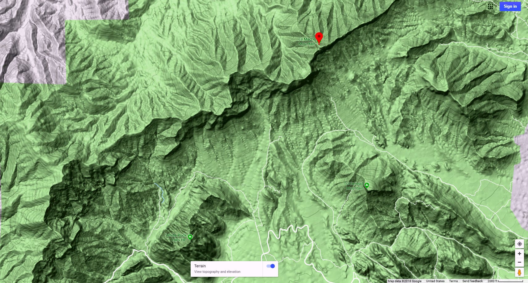
La Madre Ridgeline Base to the La Madre Mountain Northern Approach Ridgeline
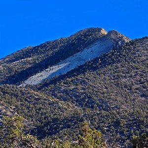
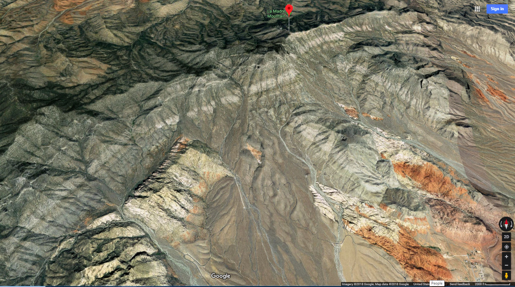
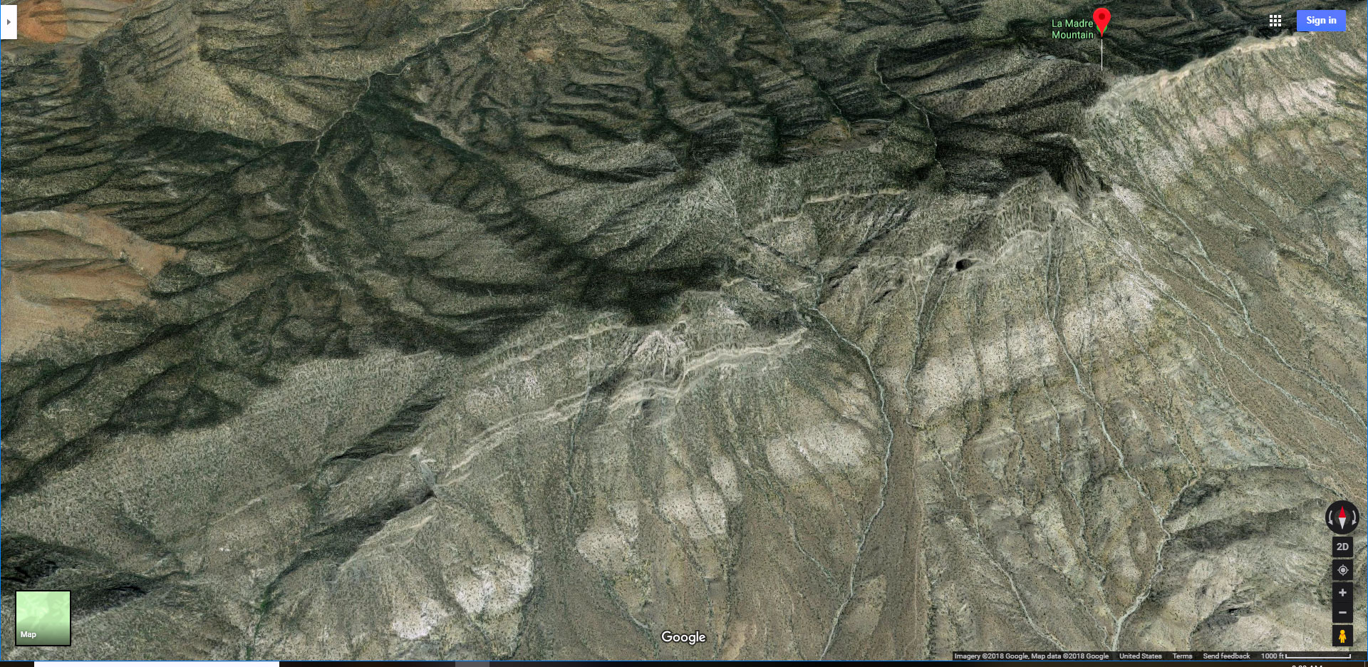
Near the base of the Eastern La Madre Ridgeline the road will split to the right, continuing West along the base of the La Madre Ridgeline. Continue on the road, in a couple miles reaching a parking area, vehicle barrier and large La Madre Wilderness entrance sign. At this point, a huge ridgeline is visible ahead. That’s the Northern La Madre Mountain Ridgeline. The vehicle-blocked road continues past the vehicle barrier all the way to the base of the Northern ridgeline. Notice how the Northern ridgeline is topped with a vertical limestone headwall stretching along the length of the ridgeline. You want to find an opening through that wall and up onto the center of the ridgeline. That opening will be at the upper left edge of the limestone headwall.
Ascending to the Center of the La Madre Mountain Northern Approach Ridgeline
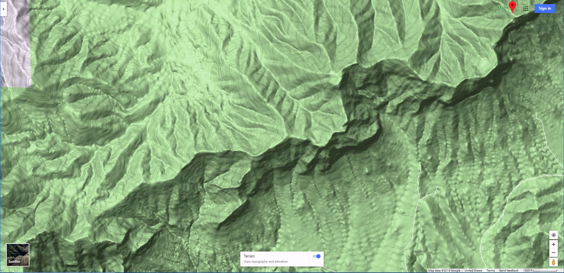
At the end of the baseline road, angle left and upward to the base of the Northern Approach Ridgeline headwall. Skirt along the base of the headwall crossing 3 low intervening ridgelines, lowest near the base of the headwall. At the upper left corner of the headwall just beyond where it turns to the West, watch for a narrow passage through the limestone headwall to the center of the Northern Ridgeline. The passage is a very brief, very light class 3 rock scramble at this point.
La Madre Mountain Northern Approach Ridgeline to the Base of La Madre Mountain and Devil’s Slide
Once on the center of the Northern Ridgeline, turn left to continue ascending that ridgeline toward its high point at the base of La Madre Mountain and Devil’s Slide. The ascent is fairly gradual through the beautiful Pinyon Pine and Juniper ridgeline forest with spectacular views all around: La Madre Mountain ahead, Mt. Charleston Wilderness to the West, Sheep Range and Gass Peak behind, Harris Springs Canyon Ridgeline with glimpses of Metro Las Vegas beyond to the East, and the Eastern La Madre Ridgeline to the Southeast! As you ascend the Northern Ridgeline toward La Madre Mountain, you’ll face a few low, easy limestone rock formations you can traverse mostly by finding steps up and over.
Summit of the Northern Approach Ridgeline
The summit of the Northern Approach Ridgeline is obvious. This is a limestone formation where the ridgeline begins to descend to the Northwest and the La Madre Campground. Alternately, you could descend a brief saddle then ascend a steep slope circling above Devil’s Slide and up to the summit of La Madre Mountain. I’ve completed and documented this stretch to La Madre Mountain Summit.
Summit of the Northern Approach Ridgeline to the La Madre Campground
For this current route, descend the Northern Approach Ridgeline to the La Madre Campground and Northern approach road below. The descent is pretty much as gradual and the ascent you just completed. However, there are a series of low (10-15ft) limestone bands you’ll need to cross on the way down. You can scramble over some of the bands where they are lower. You can cross around the lower edge of some of the bands. You want to stay in the center of the ridgeline as much as possible, not descending to far to the right or left in your attempt to cross the intervening limestone ridgelines. A way always opens up.
The La Madre Campground and Northern Approach Road
Looking down the Northern Approach Ridge, notice a large brown hill at the ridgeline base. You will connect with the low end of the campground and the La Madre Approach Road at the left base of that hill. The campground stretches along the approach road for a mile or so above the large brown hill. You can see where I passed through the La Madre Campground here.
The La Madre Campground is dispersed camping. There are many great campsites. I’ve never seen the campground fully occupied…just a few spaces taken. The campsites are generously large with places for a vehicle and tent, along with a fire ring. I believe the dispersed camping rules allow you to stay in a site for up to 2 weeks. Reservations are not required and there is no reservation system. This is a great base camp for exploring the La Madre Mountains Wilderness without the need to walk the long approach roads as I did. However, know that you will need a 4WD or high-centered vehicle to navigate the rugged, unpaved Northern approach road to the campground.
Descending Harris Springs Road
Head down the Northern Approach Road for about 2 miles to take a right onto Harris Springs Road. Continue down Harris Springs Road until it turns left toward Kyle Canyon Road in another 2 miles. For that final stretch back to the trailhead parking area where you began you have a couple choices. First, you can turn left and ascend Harris Springs Road for about a quarter-mile to Kyle Canyon Road, turn right and descend Kyle Canyon Road for the final mile to your original trailhead parking area. Alternately, you can avoid the noise of Kyle Canyon Road by angling directly across the desert between that left turn of Harris Springs Road and the trailhead parking area. You’ll need to cross a few low intervening washes along the way, but the peaceful surroundings make that worth the effort. See the map for both options. Both options take about the same time to complete.
Conclusion
This huge, unforgettable loop will give you a great experience of the Northeastern and Northcentral La Madre Wilderness and ridgeline. Along the way you’ll be sure to see many future routes above to the upper La Madre Ridgeline and below to the baseline hills and washes! One final note: All that limestone you encounter along the way is a frozen, ancient 450m-year-old seabed. You’ll be sure to find ancient sea fossils embedded in some of the limestone blocks and ledges if you look closely.


