Overview | La Madre Ridge East Base Circuit | La Madre Mountains Wilderness, Nevada
Adventure Features
Explore the very Eastern edge of the La Madre Ridgeline. Cross from Kyle Canyon to the area above Little Red Rock. Discover a cool backcountry 4WD road. Explore an approach to the La Madre Eastern Saddle.
Feeling of Remote Wilderness within Sight of Vegas
If you have a 4WD vehicle, mountain bike or are an endurance hiker, you’ve got to traverse this pristine wilderness stretch between Kyle Canyon and the Little Red Rock area! Though you can see the Vegas Metro Area below part of the time, you’ll feel as if you are hundreds of miles from civilization! There are camping possibilities and many ascent routes toward East La Madre Peak. It’s so amazing, within about 10 miles from Las Vegas as the raven flies.
Adventure Route Summary
The adventure route, on foot, begins at a parking area on lower Kyle Canyon Road, crosses Harris Springs Canyon, then takes a 4WD road up to and around the East edge of the La Madre Ridgeline. After rounding the ridgeline, skirt the base of the vertical Southern ridgeline cliffs, exploring potential routes to the ridgeline’s Eastern saddle.
Adventure Route Views
While traversing this great adventure route you will see the following (short list):
There’s much more. This is a short list.
Best Time of Year for This Adventure
The main consideration is to pick a day with the most daylight but avoid Winter snow or Summer’s dangerously high heat. My best suggestion is Fall (until Winter’s deep snow reaches below 6,000ft) and Spring (until mid-day temperatures in Las Vegas exceed 90 degrees).
Directions to Starting Point | La Madre Ridge East Base Circuit | La Madre Mountains Wilderness, Nevada
This adventure circles the La Madre Ridge East Base starting from a parking area on Kyle Canyon Road to the North. Take Hwy 95 North from Las Vegas. Exit left onto Kyle Canyon Road toward Mt. Charleston (around the end of the Northern metro area). In about 3 miles, shortly beyond the edge of the housing and horse ranch area, watch for a small trailhead parking area on the left (South) side of Kyle Canyon Road.
Narrative Guide | La Madre Ridge East Base Circuit | La Madre Mountains Wilderness, Nevada
Getting Your Initial Bearings
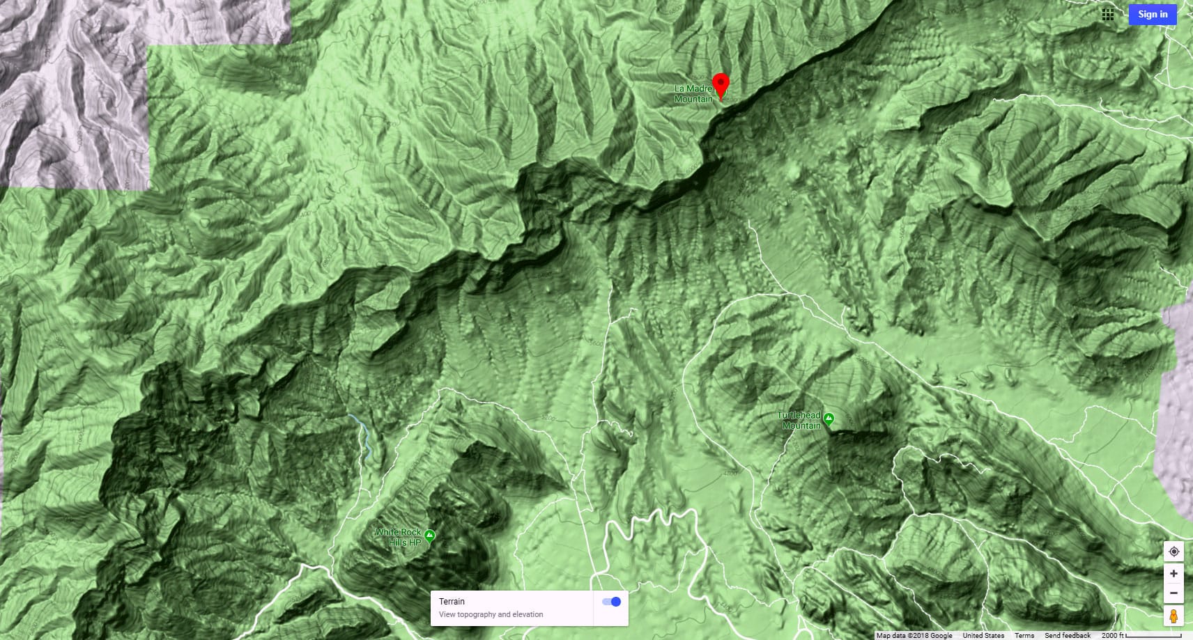
From the parking area on Kyle Canyon Road, look South to see a long ridge on the opposite side of Harris Springs Canyon. Above that ridge you can see the tip of the La Madre Ridgeline with its high peaks. Look to the left of the ridge across Harris Springs Canyon to see a tall ridgeline at the edge of Las Vegas (I call this Harris Springs Ridgeline). Notice a low point (gap) between the far right (South) edge of that ridgeline and the far left (East) edge of the La Madre Ridgeline.
You’re going to:
- Descend into Harris Springs Canyon (first 1,000ft of your adventure)
- Turn left in Harris Springs Canyon
- Navigate around the left edge of that long ridge on the opposite side of Harris Springs Canyon
- Descend into the valley along the base of the high Harris Springs Canyon Ridgeline. I call this the La Madre Approach Valley.
- Turn right on a road in that valley, ascending the road toward the now visible La Madre Ridgeline
- Take the left split in that road near the base of the La Madre Ridgeline
- Ascend that road through the gap between Harris Springs Canyon Ridgeline and the Northeastern Edge of the La Madre Ridgeline
- Continue on that road around the East base of the La Madre Ridgeline
- Descend on that road toward the now visible Little Red Rock area
- Leave the road to take a trail skirting the mid-elevation of the South side of the La Madre Ridgeline
- Leave the trail where it ends to make your way through the intervening wilderness toward the West edge of East La Madre Peak’s huge cliff (the location of the Eastern saddle)
You can see #1-7 from the parking area on Kyle Canyon Road, and imagine #8-11.
Starting Point on Kyle Canyon Road to the La Madre Approach Valley (#1-4 above)
From the parking area, take the short (blocked off to vehicles) road heading South toward Harris Springs Canyon. At the edge of the massive Harris Springs Canyon, take the left split in that road descending and winding down into the base of the canyon. Cross the canyon, angling left toward the left side of the long ridgeline on the opposite side of the canyon. There is no trail along this stretch, and there are a few gullies to navigate. Find your best route through the gullies and up to the opposite side of the canyon. There you’ll come across a trail. Take a left on that trail, then take all the trails right splits leading down to the La Madre Approach Valley below where you will find the road that will take you all the way around the East base of the La Madre Ridgeline.
La Madre Approach Valley to the Northeastern Pass of the La Madre Ridgeline
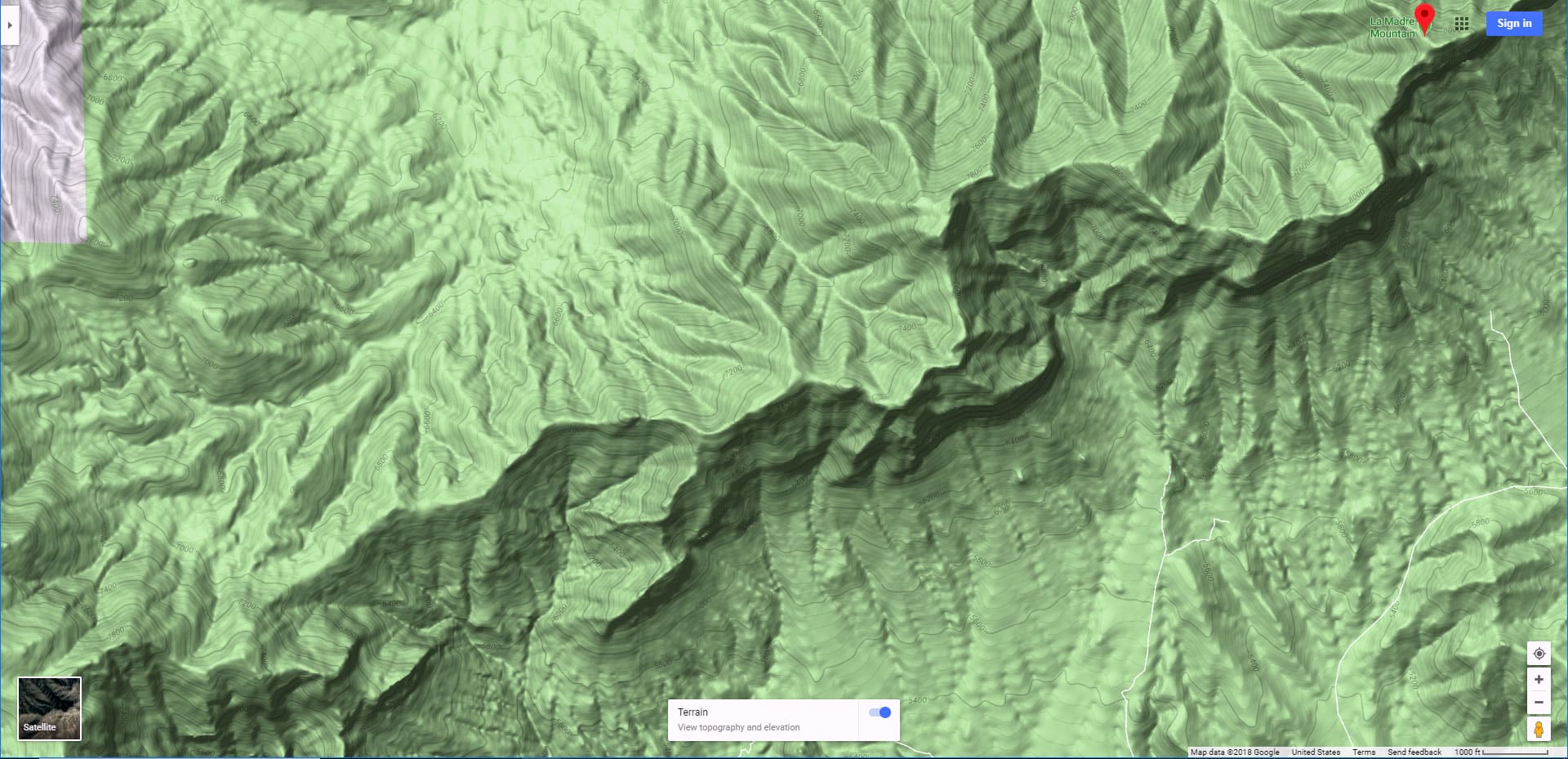
Turn right on the road in the La Madre Approach Valley and head on that road toward the now visible La Madre Ridgeline. Note on the La Madre Ridgeline the gap (Southeastern pass) between the East (left) edge of that ridgeline and the tall (6,000ft) ridgeline to your left along the approach valley. Also note a low point on the La Madre Ridgeline. That low point is the Eastern Saddle, just before the highest ridgeline peaks on the right. Ideally, you’d circle the East (left) end of the La Madre Ridgeline, then return through that saddle. I didn’t get all the way to the saddle on this adventure, but did explore Southern approach routes on the far side of the La Madre Ridgeline that got me within less than a half-mile from the saddle. View the Northern route I took earlier that reached the saddle.
Let’s get back to the road you’re on, taking you through the La Madre Approach Valley toward the La Madre Ridgeline. Near the base of the ridgeline, the road will split. Take the left split toward the Northeastern Pass (gap) above. While ascending toward the Northeastern Pass, notice a couple cool potential wilderness traverses to your right and upward toward East La Madre Peak. The wilderness area near the summit of the pass is awesome! The terrain changes from start desert to forested with Junipers and Pines. There are a number of places that would make great camping spots. In fact, the most awesome camping spots are directly above on the ridgeline cliffs. Of course, there are no amenities, bring everything you need, take out everything you bring.
Once you reach the summit area on the Southeastern pass the view dramatically begins to open ahead. There’s the Northern Las Vegas Valley, Gass Peak, and the long stretch of terrain along the East edge of the La Madre Ridgeline. You’re in a new world compared to the one behind!
Northeastern Pass to Southeastern Pass of the La Madre Ridgeline
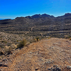
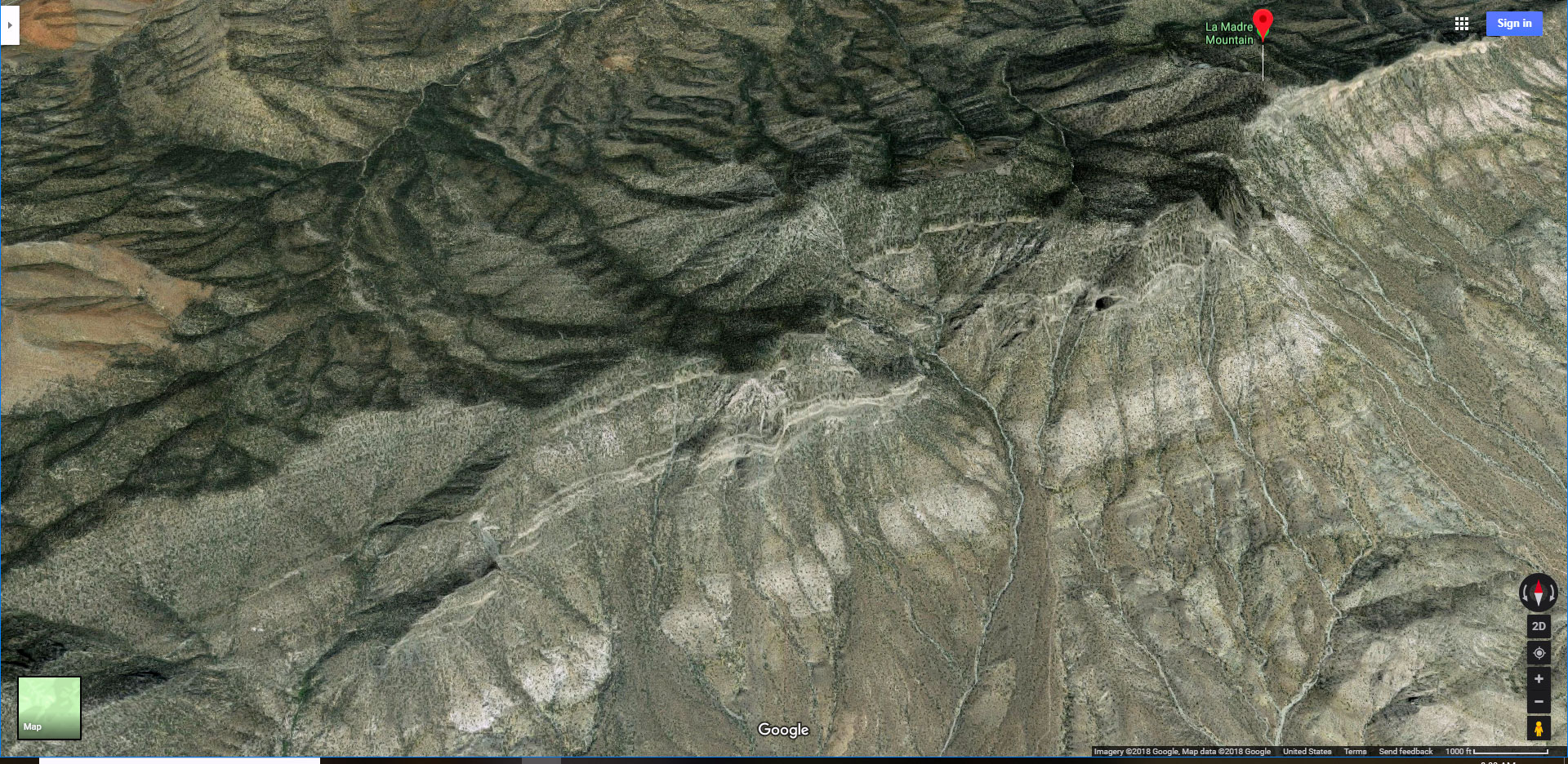
This is the approximately 3-mile stretch along the East edge of the La Madre Ridgeline. Along this stretch the ridgeline is to your right and glimpses of the Las Vegas Valley to your left. The huge valley area on this stretch is its own pristine, beautiful world. It has a “Land That Time Forgot” feel. The East edge of the La Madre Ridgeline is a gradual, but steep slope with a number of access points to the summit and beyond. These access points will lead you eventually to East La Madre Peak.
The road you are on will take you all the way through this stretch. In fact, you can see it winding through the Eastern valley all the way to the Southeastern Pass a couple miles distant (see the first slide on this page, and the feature image). The road begins with an immediate sharp and rocky descent that will be one of the two biggest challenges of the day if you’re making the trip on a bike or in a 4WD vehicle. Once you’ve made that initial descent, the incline levels off and navigation is easy. Ahead you can see a few sharp peaks descending to the base of the South side of the La Madre Ridgeline. They appear easy to climb from this, their North side. However, realize that the terrain on the South side of the La Madre Ridgeline is mostly a vertical drop! You’ll soon see.
As you approach the South side of the beautiful valley, the road winds upward, fairly gently, to the La Madre Ridge Southeastern Pass.
Southeastern Pass to Departure from the Road
Once at the summit of the Southeastern Pass, an entirely different world opens. It’s more stark and desert-like. You’ll feel as though you’re entering Red Rock Canyon. The Aztec sandstone formations of Little Red Rock appear below. To your left is the stark brown ridgeline formation containing Gottlieb and The Whale Peaks.
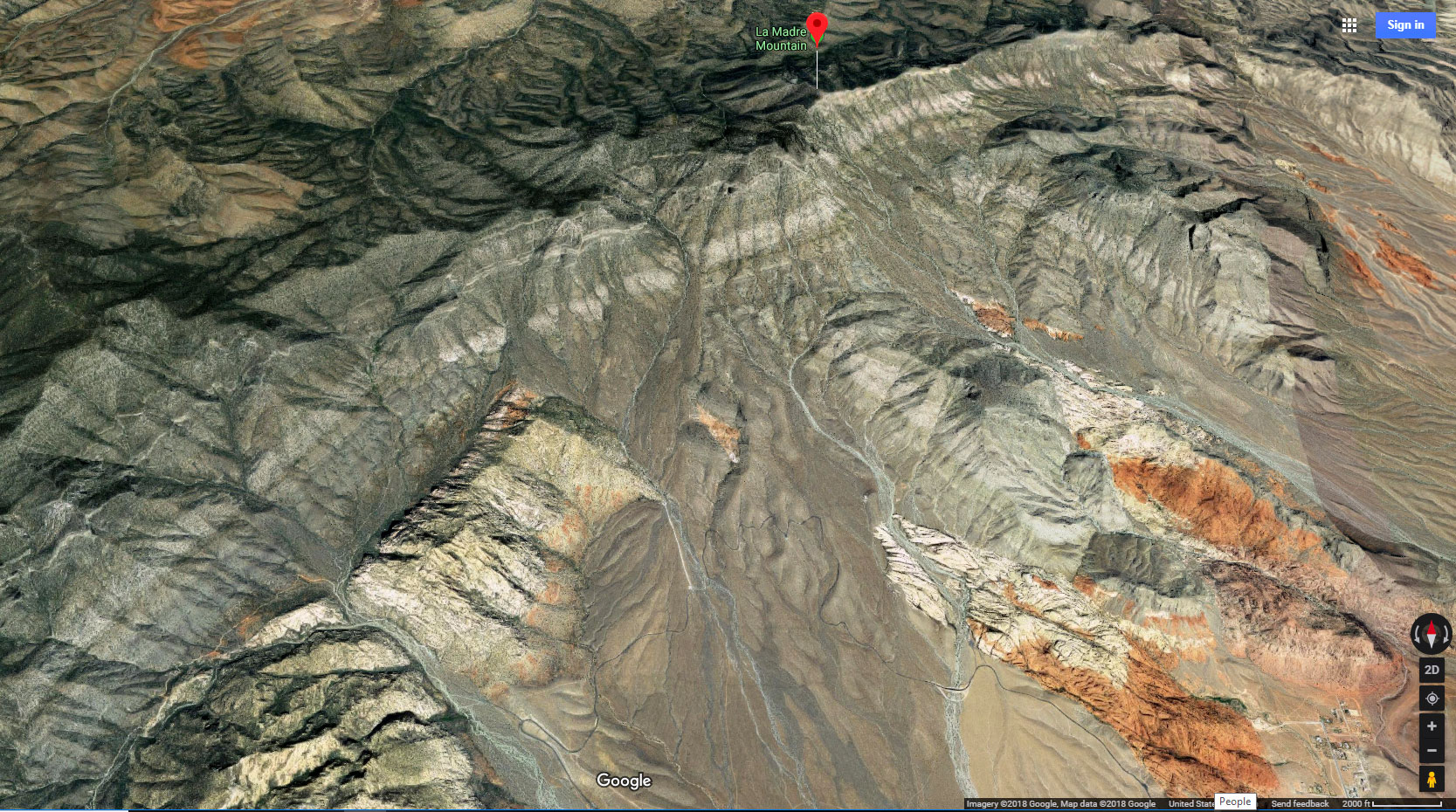
To your right is Damsel Peak. Furthest to the right are the Southern cliffs of the La Madre Ridgeline. The closest, and largest is the cliff that is the South side of East La Madre Peak. At the far end of that cliff face, it drops off forming a gap before the next cliff on the ridgeline. That gap is the Eastern ridgeline saddle and the following cliffs are the South edge of Peak 6826 and Fernande Peak.
With these landmarks in mind, the big picture of what’s next is to navigate the opening between Damsel Peak and the cliffs of the La Madre Ridgeline with a goal of reaching the Eastern ridgeline saddle. The link is to an adventure that achieved the saddle from the opposite side (North). Why is the Eastern Saddle a cool goal? To stand on the saddle is to straddle two worlds: The greener Kyle Canyon to the North with its gentle slopes and the starker desert terrain to the South with its sharp cliffs. The contrast is pretty impressive from your vantage point on the saddle.
To get to the saddle, you’ll need to cross a series of deep gullies on the way while navigating that passage between Damsel Peak and the La Madre Ridgeline. If you navigate too high along the ridgeline, as I did, the terrain up along the edge of the cliff face gets very steep and challenging. If you navigate further down, the gullies are very deep and steep. Perhaps navigating even further down along the base of the slope is the way to go. I navigated high, up close to the cliff face. The gullies were more shallow there, and easier to cross, but eventually it got so steep I had to turn around.
From the Southeastern Pass, descend the road as it sharply drops with a rocky surface similar to your descent from the Northeastern Pass. Keep to the right where the road splits. Finally take another right onto a small, unmarked trail.
Southern Trail to My Turnaround Point
The little trail will get you quite far toward the Eastern Saddle. But it gives out at a very steep gully. I headed up the ridgeline on the near side of the gully hoping to find shallower gullies closer to the cliff face. I crossed a few more gullies along the way and ended up at the edge of the cliff face where the terrain became too steep on the loose rock surface, with growing exposure to a fall. I ended up only a half-mile or less from the Eastern Saddle, which looked so close, always seeming to be just over the next ridge! However, every ridge I topped presented another gully and ridge ahead.
Even though I did not make the saddle on this adventure, just being high on the ridgeline was reward in itself! The ascent was so dramatic that the views behind became more and more expansive by the minute! There was Gottlieb and the Whale, now far below. Over those peaks, in the distance, the Muddy Mountains, Sunrise Mountain and Frenchman Mountain popped into view. To the right of Frenchman Mountain was the Las Vegas Strip, coming into sharper view in the afternoon sun. The River Mountains, Lake Mead, Railroad Mountains and North McCullough Wilderness were in view to the South. Views of Little Red Rock and Damsel Peak revealed more of their features. And the cliffs above (base of East La Madre Peak) were spectacular!
Conclusion
The ultimate goal of crossing between two worlds, the world to the South of the La Madre Ridgeline and the world to the North, will be a grand experience. However, this adventure itself, in circling the East edge of the La Madre Ridgeline, gives a unique experience of that isolated “land that time forgot”, and reveals some cool Eastern access points up the La Madre Ridgeline to East La Madre Peak.


